## Description:

Adds map of the Balkan Peninsula and surroundings. Heavily requested map
with multiple posts on the Discord all with over 10 or 20 upvotes.

23 NPC/Nations based on countries and relevant regions of the area. Adds
an extra 39 nations for crowded Humans vs Nations gamemode for a total
of 62 NPCs, based on regions of multiple countries. Also some flags for
some regions.

Source from NASA DEM, already credited

Photo of base map, and 62 HvN:


<img width="614" height="588" alt="Captura de pantalla 2026-05-24
030105"
src="https://github.com/user-attachments/assets/5742a4c3-1b1f-4ca7-858d-91529861dd81"
/>

<img width="548" height="547" alt="image"
src="https://github.com/user-attachments/assets/758d8ad0-1515-41b8-8d42-14e76cdd54ed"
/>

This map completes the quartet row of "polemic" maps for v32

<img width="678" height="119" alt="image"
src="https://github.com/user-attachments/assets/9e6f4ef1-f0cc-48ea-a59f-b7ff69033b73"
/>

## Please complete the following:

- [x] I have added screenshots for all UI updates
- [x] I process any text displayed to the user through translateText()
and I've added it to the en.json file
- [x] I have added relevant tests to the test directory
- [x] I confirm I have thoroughly tested these changes and take full
responsibility for any bugs introduced

## Please put your Discord username so you can be contacted if a bug or
regression is found:

tri.star1011
## Description:

Adds Map of the Indian Subcontinent, with indian and pakistani states
and surrounding countries, important rivers like the Ganges, Brahmaputra
and Indus, and Tibet/ theHimalayas

2M land pixels and 52 Nations (i think its fitting that India has the
most nations of a regional map, only continental maps have more)

Should be nice to boost whatever indian playerbase this game might have.
This region also doesnt have any representation aside from continental
maps

<img width="584" height="598" alt="image"
src="https://github.com/user-attachments/assets/4089049a-800b-4e37-ab34-2afc5de821e8"
/>
<img width="418" height="462" alt="image"
src="https://github.com/user-attachments/assets/a68e2424-5972-4105-86c9-0312ab095024"
/>

Elevation data from NASA DEM, already credited in CREDITS.md

No reference test is needed, the test suite automatically iterates over
all GameMapType enum values — no map is hardcoded by name in the tests

## Please complete the following:

- [x] I have added screenshots for all UI updates
- [x] I process any text displayed to the user through translateText()
and I've added it to the en.json file
- [x] I have added relevant tests to the test directory
- [x] I confirm I have thoroughly tested these changes and take full
responsibility for any bugs introduced

## Please put your Discord username so you can be contacted if a bug or
regression is found:

tri.star1011
## Description:

Resizes the Taiwan Strait map for v32, to rebalance it for 2 team games:

Yesterday the map was tested in a stream and it turned out to be
unbalanced due to the size difference of the landmasses:
https://youtu.be/gildSwTdd4I?t=2516

Adds Team spawnzones for 2 teams.

Also removes and adds new nations , suggested by its map creator
crunchybbbbb_59469 on Discord

## Please complete the following:

- [x] I have added screenshots for all UI updates
- [x] I process any text displayed to the user through translateText()
and I've added it to the en.json file
- [x] I have added relevant tests to the test directory
- [x] I confirm I have thoroughly tested these changes and take full
responsibility for any bugs introduced

## Please put your Discord username so you can be contacted if a bug or
regression is found:

tri.star1011

Taiwan Strait map by crunchybbbbb_59469 on Discord, who i worked with in
this rebalance

---------

Co-authored-by: FloPinguin <25036848+FloPinguin@users.noreply.github.com>
## Description:

Adds map of Venice. A relatively small map (similar land area to World)
for heavy trade and lots of boating.

Because of the very low difference of elevation of the zone, terrain is
instead used to show buildings.

Map source from OpenStreetMap, already credited in CREDITS.md

Very requested map, with 2 discord posts suggesting it with +15 upvotes
each

<img width="794" height="569" alt="image"
src="https://github.com/user-attachments/assets/ca7d44f2-cfc9-4e93-b7d4-43dbe62f74d4"
/>

## Please complete the following:

- [x] I have added screenshots for all UI updates
- [x] I process any text displayed to the user through translateText()
and I've added it to the en.json file
- [x] I have added relevant tests to the test directory
- [x] I confirm I have thoroughly tested these changes and take full
responsibility for any bugs introduced

## Please put your Discord username so you can be contacted if a bug or
regression is found:

tri.star1011
## Description:

Renames TheStraits map. The people that suggested this map told me they
would prefer a more specific name for the map, rather than the generic
one it has right now. So im renaming it into Danish Straits

This map is for v32, it has not been released, it should be fine to
rename


## Please complete the following:

- [x] I have added screenshots for all UI updates
- [x] I process any text displayed to the user through translateText()
and I've added it to the en.json file
- [x] I have added relevant tests to the test directory
- [x] I confirm I have thoroughly tested these changes and take full
responsibility for any bugs introduced

## Please put your Discord username so you can be contacted if a bug or
regression is found:

tri.star1011
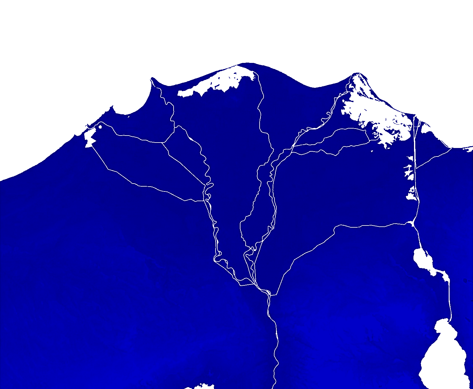
## Description:

Adds map "Northwest Passage", map of the Canadian Arctic Archipelago ,
Greenland and surroundings. "Northwest Passage" (NWP) is the sea lane
between the Atlantic and Pacific oceans
(https://en.wikipedia.org/wiki/Northwest_Passage) .

21 default nations, based on the towns of the region.

This map uses the brand new additionalNations feature made by FloPinguin
https://github.com/openfrontio/OpenFrontIO/pull/3902 . Adds 39 extra
nations for a total of 60 nations (so that in gamemodes like Humans vs
Nations all the nations have names of real places)

Comparison:
- Map with default nations
- Map with extra named nations, tested by raising the number of nations
in Solo

<img width="1050" height="412" alt="image"
src="https://github.com/user-attachments/assets/12ed94f1-0615-4fb3-b0d0-dcecb65006ea"
/>
<img width="1089" height="436" alt="image"
src="https://github.com/user-attachments/assets/6e7c11bf-7382-4e36-9433-229a9d463b68"
/>

Terrain source from OpenTopography, already credited in CREDITS.md

## Please complete the following:

- [x] I have added screenshots for all UI updates
- [x] I process any text displayed to the user through translateText()
and I've added it to the en.json file
- [x] I have added relevant tests to the test directory
- [x] I confirm I have thoroughly tested these changes and take full
responsibility for any bugs introduced

## Please put your Discord username so you can be contacted if a bug or
regression is found:

tri.star1011
## Description:

Fixes:

Various rivers with pixel-gap errors, that made players and ships unable
to boat out of the river into the sea. This error was reported in the
Discord server

<img width="876" height="481" alt="image"
src="https://github.com/user-attachments/assets/9afb31f9-f5a9-4792-bd44-3ea18fe21777"
/>


Also changes:

- Better Terrain (old version had no brown terrain and smidges of white
terrain, which made almost all the map practically green terrain). The
coastlines and terrain area remain the exact same ( the small land
change in manifest was because the old map had little random pixel lakes
all around)

- More Nations (NPCs) , more consistent names for them, and an extra
flag (Aceh)

## Please complete the following:

- [x] I have added screenshots for all UI updates
- [x] I process any text displayed to the user through translateText()
and I've added it to the en.json file
- [x] I have added relevant tests to the test directory
- [x] I confirm I have thoroughly tested these changes and take full
responsibility for any bugs introduced

## Please put your Discord username so you can be contacted if a bug or
regression is found:

tri.star1011
## Description:

**Adds "The Straits" map:**

A map located around Denmark and the many surrounding straits: Kattegat,
Skagerrak and the Danish straits (thus the name, meant to be a creative
name like "Between Two Seas" and "Gateway to the Atlantic"). This map is
themed in the early 1900s, the nations/NPCs are traditional and
historical regions of Sweden-Norway, Denmark and the Germany.

Relatively small map with ~700k land tiles, similar to World

Inspired by this Discord thread with nearly 20 upvotes:
https://canary.discord.com/channels/1284581928254701718/1482089104110911634/1482089104110911634

<img width="365" height="506" alt="image"
src="https://github.com/user-attachments/assets/5ee16218-34c0-4b8b-9f9b-d33f219760b0"
/>

## Please complete the following:

- [x] I have added screenshots for all UI updates
- [x] I process any text displayed to the user through translateText()
and I've added it to the en.json file
- [x] I have added relevant tests to the test directory
- [x] I confirm I have thoroughly tested these changes and take full
responsibility for any bugs introduced

## Please put your Discord username so you can be contacted if a bug or
regression is found:

tri.star1011
## Description:

Format the map lists in Main and MapPlaylist by alphabetical order. Many
maps were already standarized like this, but many recent ones werent.
Ideally, future maps should be added this way too.

Also ran npm run format in these 2 files, as they were not formatted
correctly before.

## Please complete the following:

- [x] I have added screenshots for all UI updates
- [x] I process any text displayed to the user through translateText()
and I've added it to the en.json file
- [x] I have added relevant tests to the test directory
- [x] I confirm I have thoroughly tested these changes and take full
responsibility for any bugs introduced

## Please put your Discord username so you can be contacted if a bug or
regression is found:

tri.star1011
## Description:

Map of the Taiwan and the Chinese Mainland.

Team heavy map like Baikal and Hormuz. Terrain Source from
OpenTopography, already credited

<img width="1800" height="1511" alt="image"
src="https://github.com/user-attachments/assets/45954469-8199-4882-9efe-899c5df87ce4"
/>

I also took the chance to standarize and sort alphabetically the map
lists in main.go and MapPlaylist.ts.

## Please complete the following:

- [x] I have added screenshots for all UI updates
- [x] I process any text displayed to the user through translateText()
and I've added it to the en.json file
- [x] I have added relevant tests to the test directory
- [x] I confirm I have thoroughly tested these changes and take full
responsibility for any bugs introduced

## Please put your Discord username so you can be contacted if a bug or
regression is found:

tri.star 1011

NOTE: If the map gets added, please give contributor to
crunchybbbbb_59469 for this map on Discord. Every file was made by him,
his PR just had weird bugs that didnt allow the PR to be review
automatically

Original PR: https://github.com/openfrontio/OpenFrontIO/pull/3853 by
crunchybbb2-hash
## Description:
Small update to Dylexdria.
Iceland (island) moved for better game play.
Edits to nation locations and additional nations added.
Entire map shifted ~120 pixels for balance reasons.


## Please complete the following:

- [x] I have added screenshots for all UI updates
- [x] I process any text displayed to the user through translateText()
and I've added it to the en.json file
- [x] I have added relevant tests to the test directory
- [x] I confirm I have thoroughly tested these changes and take full
responsibility for any bugs introduced

## Please put your Discord username so you can be contacted if a bug or
regression is found:
PlaysBadly

---------

Co-authored-by: Ricky G.P. <realtacoco@gmail.com>
## Description:

Five performance improvements to the map generator, measured on three
maps of increasing size. End-to-end time on `world` improved ~15×, heap
allocations ~19×.

| Map | Before | After | Speedup |
|-----|--------|-------|---------|
| bosphorusstraits (~612K tiles) | 578ms / 594MB | 45ms / 134MB | 13× /
4.4× |
| world (~2M tiles) | 2333ms / 2128MB | 150ms / 553MB | 15× / 3.8× |
| giantworldmap (~8M tiles) | 10701ms / 9300MB | 635ms / 2509MB | 17× /
3.7× |

Changes (one commit each):
- **`--workers` flag**: bounds concurrent map processing to limit peak
memory
- **Flat `[]bool` visited sets**: replaced `map[string]bool` keyed by
`fmt.Sprintf` with flat `[]bool` indexed `x*height+y` — the dominant
cost
- **`neighborCoords` with stack buffer**: eliminates per-call slice
allocation for neighbour lookups
- **`Terrain` struct 24→16 bytes**: field reorder + `uint8` type for
`TerrainType`
- **Nil buffers early**: releases image/terrain arrays as soon as
they're no longer needed
- **BFS mark-visited on push**: each tile enters the queue once instead
of up to 4×, halving queue memory


also fixes a bug (according to Claude):

Here's the bug: createMiniMap downscales by averaging/sampling 2x2
blocks, copying field values across — including Ocean=true from the
parent scale. When a single connected ocean at 1x splits into multiple
disconnected bodies at 4x (because narrow water channels disappear when
you halve resolution), those smaller fragments still carry Ocean=true
from the carryover. The 4x processWater call picks the new largest
fragment and sets it to Ocean=true, but never clears the others — so
multiple disconnected bodies end up flagged as Ocean.

This PR's fix: before the new BFS pass, zero out every Ocean flag, so
only the truly-largest body at the current scale ends up marked.

It's incidental to the perf work but it's a real semantic change — the
on-disk .bin files will differ from main on any map where ocean splits
across downscaling. The PR doesn't mention it, which is why I flagged
it.

---------

Co-authored-by: Copilot <223556219+Copilot@users.noreply.github.com>
## Description:

Corrected inbalance in Luna map between top and bottom. Now both sides
have about equal land tiles.
Testing and editing was done to help boat-pathing at least look normal
along bottom half.
Additional notch cut in orbit lines to take edge off boat-pathing. Now
obstacle is almost a straight line.
Filled in center orbits to help players push easier. It was reported to
be tedious previously.
'Top Secret Military Base' nation was renamed with only vowels blacked
out for easier reading of joke name.
'Monolith' nation was renamed with a special character that displays
like the actual Monolith.

<img width="829" height="1165" alt="l1"
src="https://github.com/user-attachments/assets/8cf10fbf-99c1-4ec8-ae0c-7066d1deae21"
/>

<img width="829" height="1165" alt="l2"
src="https://github.com/user-attachments/assets/828e2caf-60b3-4ac7-aa70-0f5b64fac643"
/>


## Please complete the following:

- [x] I have added screenshots for all UI updates
- [x] I process any text displayed to the user through translateText()
and I've added it to the en.json file
- [x] I have added relevant tests to the test directory
- [x] I confirm I have thoroughly tested these changes and take full
responsibility for any bugs introduced

## Discord username
PlaysBadly
## Description:

Starting v32 maps right now!

Adds map of the Middle East. Probably one of the most highly requested
maps.

Very large map (3.4M land pixels, similar to Two Lakes, would become the
2nd or 3rd largest map by land area) of the arabian peninsula and
surrounding regions.
This map has both huge areas of land without water access full of desert
terrain, and massive trade chokepoints, which combined will result in
crazy endgames.

The theme of this map are historical, based on the end of WW1.
Historical flags have been added for the nation NPCs to use.

(High map rotation of 8 since this is probably going to become one of
the most popular maps given the relevancy of the region in real life.)

Terrain source from NASA DEM, already credited.


https://github.com/user-attachments/assets/6a1b345f-fd92-42c2-8f92-154fac4c9733

## Please complete the following:

- [x] I have added screenshots for all UI updates
- [x] I process any text displayed to the user through translateText()
and I've added it to the en.json file
- [x] I have added relevant tests to the test directory
- [x] I confirm I have thoroughly tested these changes and take full
responsibility for any bugs introduced

## Please put your Discord username so you can be contacted if a bug or
regression is found:

DISCORD_USERNAME

tri.star1011
## Description:

QoL changes for the Bosphorus map.

The base image for the map had a little aliasing which resulted in some
rivers being cut off.

<img width="673" height="386" alt="image"
src="https://github.com/user-attachments/assets/b8ed181f-fbeb-4d6f-b7ab-a8b0ea300a22"
/>

All of the nations except istanbul also had absolutely nothing to do
with the region. For example, Varna is a city in Northeast bulgaria and
the aegean isles are also nowhere near. There was also a nation that did
not spawn because its coordinates were in the sea.

<img width="626" height="413" alt="image"
src="https://github.com/user-attachments/assets/a6537f79-3785-4316-8fd4-a99f55faff71"
/>

All of these poor designs are probably the result of the map being
resized, originally being a larger map. It probably explains why this is
the smallest map by land area (not counting Oceania)

Fixes:

- Fixed landlocked rivers and added More accurate bodies of water

- Complete remake of the nations. Nations are now far more accurately
placed districts of the region, and more evenly placed

<img width="664" height="407" alt="image"
src="https://github.com/user-attachments/assets/ff5a34fc-dea0-4a3d-b798-39d5711b91af"
/>

The data and gamestyle of this map should not change much, as the
landmasses remain in practice the same

## Please complete the following:

- [x] I have added screenshots for all UI updates
- [x] I process any text displayed to the user through translateText()
and I've added it to the en.json file
- [x] I have added relevant tests to the test directory
- [x] I confirm I have thoroughly tested these changes and take full
responsibility for any bugs introduced

## Please put your Discord username so you can be contacted if a bug or
regression is found:

tri.star1011
## Description:

Comprehensive accuracy and quality-of-life improvements across 8 maps.
No gameplay mechanics changed: only nation names, spawn positions, and
flag codes. All changes bring maps closer to real-world geographic and
historical accuracy.

**Changes by map:**

1. **North America:** Corrected numerous incorrect state spawn
positions. Added all 13 Canadian provinces and territories with correct
flags, as well as a few additional bots for balancing and completeness.
2. **South America:** Corrected spawn positions of Venezuela, Suriname,
and French Guiana. Added four Brazilian states (Amazonas, Pará, Bahia,
São Paulo) for better regional coverage and balancing.
3. **Gateway to the Atlantic:** Full historical consistency pass
targeting the ~1340-1410 CE period, matching the existing Britannia and
Italia map style. Renamed several nations for historical accuracy (Duchy
of Burgundy, Kingdom of Navarre, Kingdom of Majorca, City of Avignon,
Crown of Aragon, Duchy of Aquitaine, Hafsid Sultanate, Marinid
Sultanate, Zayyanid Sultanate, Holy Roman Empire). Added 7 new
historically accurate flag SVGs for these nations.
4. **Europe:** Shortened long-form nation names to short-form for
consistency with other maps. Added Andorra and Monaco for improved
balance.
5. **Europe Classic:** Fixed "Syrian Arab Republic" to "Syria" for
consistency with all other maps. Added Baltic states, Croatia, Denmark,
Sápmi for balancing.
6. **Oceania:** Removed ghost bots that no longer appear on the map.
Fixed truncated and outdated names: Lao PDR to Laos, Brunei Darussalam
to Brunei, TimorLeste to Timor Leste, Taiwan Province of China to
Taiwan.
7. **World:** Fixed outdated names for accuracy and consistency with the
World map and other maps. Added bots in regions lacking coverage for
more consistent global representation.
8. **Giant World Map:** Updated nation names for accuracy and
consistency. Added Canadian provinces, US states, Bolivia, and Gabon for
improved map balance.

All changes made and verified in the map editor. No en.json or UI
changes required as these are map data files only.

## Please complete the following:
- [x] I have added screenshots for all UI updates
- [x] I process any text displayed to the user through translateText()
and I've added it to the en.json file
- [x] I have added relevant tests to the test directory
- [x] I confirm I have thoroughly tested these changes and take full
responsibility for any bugs introduced

## Please put your Discord username so you can be contacted if a bug or
regression is found:
@islandspiritozempic
## Description:
Removed single pixel line from the bottom of LA map.
Added L.A.X. nation to LA map.
Removed USSR flags from Dyslexdria (originally imported from giant world
map). Left USSR flag on 'Rusha' only.

## Please complete the following:

- [x] I have added screenshots for all UI updates
- [x] I process any text displayed to the user through translateText()
and I've added it to the en.json file
- [x] I have added relevant tests to the test directory
- [x] I confirm I have thoroughly tested these changes and take full
responsibility for any bugs introduced

## Please put your Discord username
PlaysBadly
## Description:

Change inspired by Territorial.io . Renames the Mediterranean sea map to
Mare Nostrum, the ancient name of the sea given by the Romans. The NPCs
of the map are already roman provinces, so this change is more thematic
and also adds a creative name like "Gateway to the Atlantic" and
"Between Two Seas"

## Please complete the following:

- [x] I have added screenshots for all UI updates
- [x] I process any text displayed to the user through translateText()
and I've added it to the en.json file
- [x] I have added relevant tests to the test directory
- [x] I confirm I have thoroughly tested these changes and take full
responsibility for any bugs introduced

## Please put your Discord username so you can be contacted if a bug or
regression is found:

tri.star1011
## Description:
Add Map - Los Angeles (With Roads)
Whats NY without LA? What is LA without its roads? Here is a larger map
where I have turned LAs road network into rivers. Nations named to areas
of the city or surrounding area. Map geo data is from OpenTopography. I
stenciled the highways from screenshots of online maps and some artistic
choice.
https://discord.com/channels/1284581928254701718/1482605671697613081/1482605671697613081https://www.youtube.com/watch?v=6td9wiQKE9s
## Please complete the following:
- [x] I have added screenshots for all UI updates
- [x] I process any text displayed to the user through translateText()
and I've added it to the en.json file
- [x] I have added relevant tests to the test directory
- [x] I confirm I have thoroughly tested these changes and take full
responsibility for any bugs introduced
##Discord username
PlaysBadly
---------
Co-authored-by: evanpelle <evanpelle@gmail.com>
## Description:

Adds map of the Baja California peninsula in Mexico. Majority of this
map is brown terrain to simulate the (Sonora) desert
Mexican and American states as NPCs. The peninsula while having little
landmass is balanced by the fact it will be very easy to pirate from it

<img width="503" height="583" alt="Captura de pantalla 2026-04-18
151337"
src="https://github.com/user-attachments/assets/b1acd93a-fbe4-4d17-95b6-5f4c86ec872f"
/>

Relief data from OpenTopography, already credited

## Please complete the following:

- [x] I have added screenshots for all UI updates
- [x] I process any text displayed to the user through translateText()
and I've added it to the en.json file
- [x] I have added relevant tests to the test directory
- [x] I confirm I have thoroughly tested these changes and take full
responsibility for any bugs introduced

## Please put your Discord username so you can be contacted if a bug or
regression is found:

tri.star1011
## Description:

Small-island removal previously ran only on the full-size terrain. The
compact (4x downscaled) map inherited that filtering before being
downscaled, which meant islands that survived at full size could end up
as tiny specks in the compact map.

This PR runs `removeSmallIslands` on the 4x terrain as well, with half
the threshold (15 vs 30 tiles), so very small islands are pruned in
compact maps while the full-size map is unchanged.

## Please complete the following:

- [X] I have added screenshots for all UI updates
- [X] I process any text displayed to the user through translateText()
and I've added it to the en.json file
- [X] I have added relevant tests to the test directory
- [X] I confirm I have thoroughly tested these changes and take full
responsibility for any bugs introduced

## Please put your Discord username so you can be contacted if a bug or
regression is found:

FloPinguin
## Description:

Adds Archipelago Sea map. The island map to end all island maps.

This is a real location in Southwest Finland, famous for being the
archipelago with the most islands in the world.

This map is made for the very loud playerbase who enjoys naval maps.
This is probably the most heavy naval map we are gonna get. Given this
is a very experimental and unorthodox map like amazon or 4islands, it
has a rotation of 3 , low but still should pop in for people who prefer
island maps.


https://github.com/user-attachments/assets/19b32a4f-825b-4b82-aec3-b24c387b9cdd

## Please complete the following:

- [x] I have added screenshots for all UI updates
- [x] I process any text displayed to the user through translateText()
and I've added it to the en.json file
- [x] I have added relevant tests to the test directory
- [x] I confirm I have thoroughly tested these changes and take full
responsibility for any bugs introduced

## Please put your Discord username so you can be contacted if a bug or
regression is found:

tri.star1011
## Description:

(re-submission of older PR because the old one had too many merge
conflicts)

Re-adds and reworks the previously April Fools "Reglaciated Antarctica"
as a new map, this time with proper elevation data: Map of Antarctica
centered in the South Pole.

The "appeal" of this a map is that it has no green terrain. (As such it
has a really low rotation number (of 1). )

This also completes the Continental map category (antarctica was the
only continent out of the traditional 7 missing).


https://github.com/user-attachments/assets/28302464-c533-483e-8a1b-2699093921ff

The base map image is a composite of 2 relief maps from 2 different
sources, both properly credited

## Please complete the following:

- [x] I have added screenshots for all UI updates
- [x] I process any text displayed to the user through translateText()
and I've added it to the en.json file
- [x] I have added relevant tests to the test directory
- [x] I confirm I have thoroughly tested these changes and take full
responsibility for any bugs introduced

## Please put your Discord username so you can be contacted if a bug or
regression is found:

tri.star1011

Co-authored-by: iamlewis <lewismmmm@gmail.com>
## Description:

Similar to how Europe classic was taken off rotation, we do the same
with Britannia. The newer Britannia was slightly updated to include the
rivers of the classic version, this is because of feedback from players
in the discord server who say the rivers in the classic version are an
important part of gameplay. Map otherwise keeps same nations and size.

## Please complete the following:

- [x] I have added screenshots for all UI updates
- [x] I process any text displayed to the user through translateText()
and I've added it to the en.json file
- [x] I have added relevant tests to the test directory
- [x] I confirm I have thoroughly tested these changes and take full
responsibility for any bugs introduced

## Please put your Discord username so you can be contacted if a bug or
regression is found:

tri.star1011
## Description:

Re-submission of older PR:
https://github.com/openfrontio/OpenFrontIO/pull/3617
<img width="612" height="396" alt="image"
src="https://github.com/user-attachments/assets/955a0b2e-1df9-4fa3-a389-235f46a90f69"
/>

Regarding Bering Sea and Bering strait maps:
<img width="576" height="87" alt="image"
src="https://github.com/user-attachments/assets/f57031eb-f9c0-4e1e-83ff-204df51bb6c2"
/>
<img width="589" height="93" alt="image"
src="https://github.com/user-attachments/assets/629e71ba-489f-41cf-b67e-2476af8704f2"
/>

Because of mixed opinions about replacing the maps, i propose at least
this temporary compromise: Bering Sea gets added as a new map and Bering
Strait gets its rotation lowered to a small number. Since the classic
maps are probably being taken off rotation, we should have some small
breathing space for the 2 maps.

In the near future we should discuss between mapmakers in the dev server
whether we keep, replace or completely take Bering Strait off rotation,
and/or a community poll.

## Please complete the following:

- [x] I have added screenshots for all UI updates
- [x] I process any text displayed to the user through translateText()
and I've added it to the en.json file
- [x] I have added relevant tests to the test directory
- [x] I confirm I have thoroughly tested these changes and take full
responsibility for any bugs introduced

## Please put your Discord username so you can be contacted if a bug or
regression is found:

tri.star1011
## Description:

Updates Luna map so that 'orbit' lines are continuous during compact
game play. Other small edits.

https://youtu.be/rxoME-YYtII

## Please complete the following:

- [x] I have added screenshots for all UI updates
- [x] I process any text displayed to the user through translateText()
and I've added it to the en.json file
- [x] I have added relevant tests to the test directory
- [x] I confirm I have thoroughly tested these changes and take full
responsibility for any bugs introduced

## Please put your Discord username so you can be contacted if a bug or
regression is found:

PlaysBadly
## Description:

I found a better dataset of the region so:
Update of the Great lakes with better terrain and more accurate water.
Nations and map size all stay the same.

<img width="918" height="306" alt="image"
src="https://github.com/user-attachments/assets/a4a68727-662f-4603-b61c-9969a2a35500"
/>

Describe the PR.

## Please complete the following:

- [x] I have added screenshots for all UI updates
- [x] I process any text displayed to the user through translateText()
and I've added it to the en.json file
- [x] I have added relevant tests to the test directory
- [x] I confirm I have thoroughly tested these changes and take full
responsibility for any bugs introduced

## Please put your Discord username so you can be contacted if a bug or
regression is found:

tri.star1011
## Description:

Adds the Sahara to the Mediterranean map (in the current version it is
green, it has been manually changed to brown terrain for more realism
and to make expansion in the south a little harder since it is where
most bots would spawn)

<img width="995" height="280" alt="image"
src="https://github.com/user-attachments/assets/bea152bf-027f-4ec5-8560-206978475ef3"
/>

## Please complete the following:

- [x] I have added screenshots for all UI updates
- [x] I process any text displayed to the user through translateText()
and I've added it to the en.json file
- [x] I have added relevant tests to the test directory
- [x] I confirm I have thoroughly tested these changes and take full
responsibility for any bugs introduced

## Please put your Discord username so you can be contacted if a bug or
regression is found:

tri.star1011
## Description:

Adds spawn areas to the Luna map for 2 teams, given the map is very
symmetrical and would fit nicely with other team-centered maps like
baikal and 4islands. Thanks to deshack for suggesting this.

<img width="226" height="527" alt="image"
src="https://github.com/user-attachments/assets/8c3776d9-dfff-4bdf-a0ec-81d45daa61af"
/>


## Please complete the following:

- [x] I have added screenshots for all UI updates
- [x] I process any text displayed to the user through translateText()
and I've added it to the en.json file
- [x] I have added relevant tests to the test directory
- [x] I confirm I have thoroughly tested these changes and take full
responsibility for any bugs introduced

## Please put your Discord username so you can be contacted if a bug or
regression is found:

tri.star1011
## Description:

Adds map of the Caucasus. This map is made especifically because of the
new update that allows ports to be placed on smaller bodies of water,
rather than just the largest one.

This map has 2 disconnected, large bodies of water of similar size
(Black and Caspian seas), which would create 2 independent trade
systems, creating a more dynamic economy.

<img width="667" height="541" alt="Captura de pantalla 2026-04-13
195810"
src="https://github.com/user-attachments/assets/d980b831-d920-4a2e-9d92-40a7be96ead6"
/>
<img width="539" height="439" alt="Captura de pantalla 2026-04-13
200005"
src="https://github.com/user-attachments/assets/e973a66a-8796-40dc-b8b3-39b49f687609"
/>

## Please complete the following:

- [x] I have added screenshots for all UI updates
- [x] I process any text displayed to the user through translateText()
and I've added it to the en.json file
- [x] I have added relevant tests to the test directory
- [x] I confirm I have thoroughly tested these changes and take full
responsibility for any bugs introduced

## Please put your Discord username so you can be contacted if a bug or
regression is found:

tri.star1011
## Description:

Adds flags to the NPCs / Nations of the Arctic and Mediterranean maps.

Also: fixed Nunavut and Yukon flags which were not working and renamed
the "SPQR" flag to Roman Empire since thats what players are most likely
to search when picking the flag

## Please complete the following:

- [x] I have added screenshots for all UI updates
- [x] I process any text displayed to the user through translateText()
and I've added it to the en.json file
- [x] I have added relevant tests to the test directory
- [x] I confirm I have thoroughly tested these changes and take full
responsibility for any bugs introduced

## Please put your Discord username so you can be contacted if a bug or
regression is found:

tri.star1011
## Description:
Add Map - Conakry
Dataset from OpenTopography. Map rotated 45 degrees from north. This is
a 'long' map in a similar catagory as Amazon River with public rotation
adjusted to match. Different than Amazon in that its stubbier, one
sided, and has various terrain obstacles. Also its a really cool looking
piece of geography.
https://www.youtube.com/watch?v=OsMDbnnOOkohttps://discord.com/channels/1284581928254701718/1481689305960288477/1481689305960288477
I removed an additional bot from the far left to help balance the map.
Some rivers were extended past realism to help section off the map in
areas. Size of map kept below average intentionally.
## Please complete the following:
- [x] I have added screenshots for all UI updates
- [x] I process any text displayed to the user through translateText()
and I've added it to the en.json file
- [x] I have added relevant tests to the test directory
- [x] I confirm I have thoroughly tested these changes and take full
responsibility for any bugs introduced
## Please put your Discord username
PlaysBadly
## Description:

This was a proposal in the map channel of the dev discord server:

**Updates the Europe map to include Iceland, and removes Classic Europe
off rotation.** Classic Europe will remain in custom private map list

The only thing the new europe map didnt have from the classic version
was iceland, so i figured we should update the europe map to contain it,
since Iceland is a popular spawn in the classic version. Iceland is in
the same position as the classic map

The classic europe is frankly a lesser version of the new map as it
doesnt contain rivers , is smaller and the terrain has less quality, and
with the updated version, classic would just take up very needed space
in the lobby queue. We currently have a very large number of maps, which
results in players having to wait for a long time for an specific map in
public lobbies. This should help the issue a little at the very least.

<img width="2905" height="1674" alt="image"
src="https://github.com/user-attachments/assets/da98d935-b927-4e04-9383-9a1f2b794f97"
/>

## Please complete the following:

- [x] I have added screenshots for all UI updates
- [x] I process any text displayed to the user through translateText()
and I've added it to the en.json file
- [x] I have added relevant tests to the test directory
- [x] I confirm I have thoroughly tested these changes and take full
responsibility for any bugs introduced

## Please put your Discord username so you can be contacted if a bug or
regression is found:

tri.star1011
## Description:
Adition of Strait of Malacca map

It adds a new map, requested by
Coolson
awildcoolson
Describe the PR.
The map added is a map inspired by the strait of Malacca, it contains
two large landmasses and some islands
## Please complete the following:

- [x] I have added screenshots for all UI updates
- [x] I process any text displayed to the user through translateText()
and I've added it to the en.json file
- [x] I have added relevant tests to the test directory
- [x] I confirm I have thoroughly tested these changes and take full
responsibility for any bugs introduced

## Please put your Discord username so you can be contacted if a bug or
regression is found:

lerithmercano

---------

Co-authored-by: Ricky G.P. <realtacoco@gmail.com>
Co-authored-by: VariableVince <24507472+VariableVince@users.noreply.github.com>
## Description:

Highly requested map. Map of the 5 Great Lakes (Superior, Michigan,
Huron, Erie and Ontario) with adjacent rivers and lakes. Local cities
and towns as nations / NPCs.


https://github.com/user-attachments/assets/157346fa-e3e6-4d63-9f51-46bae002d529

(Kinda obvious we needed this location at some point)

## Please complete the following:

- [x] I have added screenshots for all UI updates
- [x] I process any text displayed to the user through translateText()
and I've added it to the en.json file
- [x] I have added relevant tests to the test directory
- [x] I confirm I have thoroughly tested these changes and take full
responsibility for any bugs introduced

## Please put your Discord username so you can be contacted if a bug or
regression is found:

tri.star1011
## Description:

Map-Generator README:

- Add needed step to open map-generator folder before installing
depenencies and running the generator. Otherwise errors will arise.

- And add last step to run Prettier with some information on other
options, as map makers aren't generally developers per se.

- Reword/reorder a bit for easier understanding.

## Please complete the following:

- [x] I have added screenshots for all UI updates
- [x] I process any text displayed to the user through translateText()
and I've added it to the en.json file
- [x] I have added relevant tests to the test directory
- [x] I confirm I have thoroughly tested these changes and take full
responsibility for any bugs introduced

## Please put your Discord username so you can be contacted if a bug or
regression is found:

tryout33

---------

Co-authored-by: coderabbitai[bot] <136622811+coderabbitai[bot]@users.noreply.github.com>
## Description:
Re Add map Dyslexdria. I adjusted the rivers to make boat traffic go
through main channels isntead of shortcuts. Flags adjusted. Correct
thumbnail added

## Please complete the following:

- [x] I have added screenshots for all UI updates
- [x] I process any text displayed to the user through translateText()
and I've added it to the en.json file
- [x] I have added relevant tests to the test directory
- [x] I confirm I have thoroughly tested these changes and take full
responsibility for any bugs introduced

## Discord username
Plays Badly
Re-submission, previous request was not branched properly.


## Description:

Add custom map Dyslexdria. Based off of large_world_map_recolor.tif and
rivers from the XL World map. Map is intended for long term use.
Suggesting that map be used as an April Fools gag by replacing thumbnail
and title with 'World' during first run.

<img width="995" height="721" alt="dyslexdria screenshot"
src="https://github.com/user-attachments/assets/8826839f-b4e0-431d-af9c-0b0e43dc601d"
/>

- [x] I have added screenshots for all UI updates
- [x] I process any text displayed to the user through translateText()
and I've added it to the en.json file
- [x] I have added relevant tests to the test directory
- [x] I confirm I have thoroughly tested these changes and take full
responsibility for any bugs introduced


## Following:

- Build log, screen shots, and test videos.
https://discord.com/channels/1284581928254701718/1456890656147374080


## Discord username:

PlaysBadly

---------

Co-authored-by: Duwibi <86431918+Duwibi@users.noreply.github.com>
Co-authored-by: VariableVince <24507472+VariableVince@users.noreply.github.com>
## Description:
Requesting that these 4 maps be added temporarily for the April Fools
holiday. Included are:
- A wider version of the Amazon River to allow for larger ships.
- An edit of The Box with more varied terrain.
- A modification to The World which optimizes play for mobile users.
- A custom remix to Antarctica which re-adds ice to the map.
All maps are edits of existing work. All maps have been added as their
own individual map files rather than edits to existing files for ease of
management.

<img width="912" height="1067" alt="temp"
src="https://github.com/user-attachments/assets/089ef59f-8bdf-4c86-b479-620b8c220c3a"
/>
https://discord.com/channels/1284581928254701718/1483786939332169830

- [x] I have added screenshots for all UI updates
- [x] I process any text displayed to the user through translateText()
and I've added it to the en.json file
- [x] I have added relevant tests to the test directory
- [x] I confirm I have thoroughly tested these changes and take full
responsibility for any bugs introduced

## Discord username

PlaysBadly
## Description:

Adds Mediterranean sea map, from Iberia to Asia. Map contains ancient
Roman Empire provinces and its rivals as Nations.
This map was requested by the dev.

elevation data from Opentopography

<img width="2850" height="1450" alt="image"
src="https://github.com/user-attachments/assets/6aa5ba12-f4f7-414d-a712-b90323f1d796"
/>
<img width="590" height="304" alt="Captura de pantalla 2026-03-27
010038"
src="https://github.com/user-attachments/assets/efd1deea-bd88-4ae2-92a0-47a6626a0c0f"
/>
<img width="585" height="302" alt="Captura de pantalla 2026-03-27
005758"
src="https://github.com/user-attachments/assets/a127696e-fe34-424c-a88d-b86b99a5f414"
/>


## Please complete the following:

- [x] I have added screenshots for all UI updates
- [x] I process any text displayed to the user through translateText()
and I've added it to the en.json file
- [x] I have added relevant tests to the test directory
- [x] I confirm I have thoroughly tested these changes and take full
responsibility for any bugs introduced

## Please put your Discord username so you can be contacted if a bug or
regression is found:

tri.star1011
## Description:

Adds Milky Way galaxy map based on real reconstruction by NASA. Star
density simulated as terrain. Best played in Dark Mode.

Also adds credits to JPL NASA

<img width="532" height="533" alt="Captura de pantalla 2026-03-26
142938"
src="https://github.com/user-attachments/assets/87bb19bb-4e2d-4383-a3e9-6e14b714b84c"
/>

## Please complete the following:

- [x] I have added screenshots for all UI updates
- [x] I process any text displayed to the user through translateText()
and I've added it to the en.json file
- [x] I have added relevant tests to the test directory
- [x] I confirm I have thoroughly tested these changes and take full
responsibility for any bugs introduced

## Please put your Discord username so you can be contacted if a bug or
regression is found:

tri.star1011
## Description:

Introduces 4 new private match maps for the OFM tournament in May.
Includes 2, 3, 4, and 8 player maps. Playtested, and include as many
default nations as the map expects players, named after compass points.
Give it a try at https://tourney-maps.openfront.dev/

<img width="1500" height="1500" alt="image"
src="https://github.com/user-attachments/assets/9138b636-5dd7-4118-82e2-50a5125a7963"
/>

The base images were created from scratch based on prototype designs,
and they were converted from vector versions I made. I haven't decided
on what the names should be for the maps themselves, so for now they're
just `Tourney Map 1`, `Tourney Map 2`, etc. Ideas welcome.


## Please complete the following:

- [x] I have added screenshots for all UI updates
- [x] I process any text displayed to the user through translateText()
and I've added it to the en.json file
- [x] I have added relevant tests to the test directory
- [x] I confirm I have thoroughly tested these changes and take full
responsibility for any bugs introduced

## Please put your Discord username so you can be contacted if a bug or
regression is found:

bijx
## Description:

Expands the Aegean map to the left. Currently the 2 major landmasses are
unbalanced, which causes the eastern side to almost always win, both in
FFA and team games.

Original Width: 1600px | New Width=1700px

Also adds more nations / NPCs in the Greek side to create more balance
with the Turkish side, aswell as in the islands, to compensate for the
lack of bots / tribes spawning in there, to boost early island gameplay
and fasten games.

<img width="355" height="415" alt="image"
src="https://github.com/user-attachments/assets/066d86cd-5a6b-4a07-bfa4-264b7ef82a3c"
/>


## Please complete the following:

- [x] I have added screenshots for all UI updates
- [x] I process any text displayed to the user through translateText()
and I've added it to the en.json file
- [x] I have added relevant tests to the test directory
- [x] I confirm I have thoroughly tested these changes and take full
responsibility for any bugs introduced

## Please put your Discord username so you can be contacted if a bug or
regression is found:

tri.star1011
## Description:

"Baikal (Nuke Wars)" has teamGameSpawnAreas (for Random Spawn), but
Baikal not. Because teamGameSpawnAreas was intended for a "Nuke Wars"
modifier. Let's add teamGameSpawnAreas also to Baikal to improve random
spawning (special rotation) a bit (until we have a better random spawn
algo).

## Please complete the following:

- [X] I have added screenshots for all UI updates
- [X] I process any text displayed to the user through translateText()
and I've added it to the en.json file
- [X] I have added relevant tests to the test directory
- [X] I confirm I have thoroughly tested these changes and take full
responsibility for any bugs introduced

## Please put your Discord username so you can be contacted if a bug or
regression is found:

FloPinguin
## Description:

This PR registers the straitofhormuz map in main.go. This ensures that
the map is processed and included when running the map generator, as it
was previously present in the resources but missing from the generation
pipeline.

## Please complete the following:

- [X] I have added screenshots for all UI updates
- [X] I process any text displayed to the user through translateText()
and I've added it to the en.json file
- [X] I have added relevant tests to the test directory
- [X] I confirm I have thoroughly tested these changes and take full
responsibility for any bugs introduced

## Please put your Discord username so you can be contacted if a bug or
regression is found:

TSProphet