## Description:

Format the map lists in Main and MapPlaylist by alphabetical order. Many
maps were already standarized like this, but many recent ones werent.
Ideally, future maps should be added this way too.

Also ran npm run format in these 2 files, as they were not formatted
correctly before.

## Please complete the following:

- [x] I have added screenshots for all UI updates
- [x] I process any text displayed to the user through translateText()
and I've added it to the en.json file
- [x] I have added relevant tests to the test directory
- [x] I confirm I have thoroughly tested these changes and take full
responsibility for any bugs introduced

## Please put your Discord username so you can be contacted if a bug or
regression is found:

tri.star1011
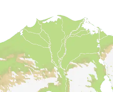
## Description:

Map of the Taiwan and the Chinese Mainland.

Team heavy map like Baikal and Hormuz. Terrain Source from
OpenTopography, already credited

<img width="1800" height="1511" alt="image"
src="https://github.com/user-attachments/assets/45954469-8199-4882-9efe-899c5df87ce4"
/>

I also took the chance to standarize and sort alphabetically the map
lists in main.go and MapPlaylist.ts.

## Please complete the following:

- [x] I have added screenshots for all UI updates
- [x] I process any text displayed to the user through translateText()
and I've added it to the en.json file
- [x] I have added relevant tests to the test directory
- [x] I confirm I have thoroughly tested these changes and take full
responsibility for any bugs introduced

## Please put your Discord username so you can be contacted if a bug or
regression is found:

tri.star 1011

NOTE: If the map gets added, please give contributor to
crunchybbbbb_59469 for this map on Discord. Every file was made by him,
his PR just had weird bugs that didnt allow the PR to be review
automatically

Original PR: https://github.com/openfrontio/OpenFrontIO/pull/3853 by
crunchybbb2-hash
## Description:

Five performance improvements to the map generator, measured on three
maps of increasing size. End-to-end time on `world` improved ~15×, heap
allocations ~19×.

| Map | Before | After | Speedup |
|-----|--------|-------|---------|
| bosphorusstraits (~612K tiles) | 578ms / 594MB | 45ms / 134MB | 13× /
4.4× |
| world (~2M tiles) | 2333ms / 2128MB | 150ms / 553MB | 15× / 3.8× |
| giantworldmap (~8M tiles) | 10701ms / 9300MB | 635ms / 2509MB | 17× /
3.7× |

Changes (one commit each):
- **`--workers` flag**: bounds concurrent map processing to limit peak
memory
- **Flat `[]bool` visited sets**: replaced `map[string]bool` keyed by
`fmt.Sprintf` with flat `[]bool` indexed `x*height+y` — the dominant
cost
- **`neighborCoords` with stack buffer**: eliminates per-call slice
allocation for neighbour lookups
- **`Terrain` struct 24→16 bytes**: field reorder + `uint8` type for
`TerrainType`
- **Nil buffers early**: releases image/terrain arrays as soon as
they're no longer needed
- **BFS mark-visited on push**: each tile enters the queue once instead
of up to 4×, halving queue memory


also fixes a bug (according to Claude):

Here's the bug: createMiniMap downscales by averaging/sampling 2x2
blocks, copying field values across — including Ocean=true from the
parent scale. When a single connected ocean at 1x splits into multiple
disconnected bodies at 4x (because narrow water channels disappear when
you halve resolution), those smaller fragments still carry Ocean=true
from the carryover. The 4x processWater call picks the new largest
fragment and sets it to Ocean=true, but never clears the others — so
multiple disconnected bodies end up flagged as Ocean.

This PR's fix: before the new BFS pass, zero out every Ocean flag, so
only the truly-largest body at the current scale ends up marked.

It's incidental to the perf work but it's a real semantic change — the
on-disk .bin files will differ from main on any map where ocean splits
across downscaling. The PR doesn't mention it, which is why I flagged
it.

---------

Co-authored-by: Copilot <223556219+Copilot@users.noreply.github.com>
## Description:

Starting v32 maps right now!

Adds map of the Middle East. Probably one of the most highly requested
maps.

Very large map (3.4M land pixels, similar to Two Lakes, would become the
2nd or 3rd largest map by land area) of the arabian peninsula and
surrounding regions.
This map has both huge areas of land without water access full of desert
terrain, and massive trade chokepoints, which combined will result in
crazy endgames.

The theme of this map are historical, based on the end of WW1.
Historical flags have been added for the nation NPCs to use.

(High map rotation of 8 since this is probably going to become one of
the most popular maps given the relevancy of the region in real life.)

Terrain source from NASA DEM, already credited.


https://github.com/user-attachments/assets/6a1b345f-fd92-42c2-8f92-154fac4c9733

## Please complete the following:

- [x] I have added screenshots for all UI updates
- [x] I process any text displayed to the user through translateText()
and I've added it to the en.json file
- [x] I have added relevant tests to the test directory
- [x] I confirm I have thoroughly tested these changes and take full
responsibility for any bugs introduced

## Please put your Discord username so you can be contacted if a bug or
regression is found:

DISCORD_USERNAME

tri.star1011
## Description:

Change inspired by Territorial.io . Renames the Mediterranean sea map to
Mare Nostrum, the ancient name of the sea given by the Romans. The NPCs
of the map are already roman provinces, so this change is more thematic
and also adds a creative name like "Gateway to the Atlantic" and
"Between Two Seas"

## Please complete the following:

- [x] I have added screenshots for all UI updates
- [x] I process any text displayed to the user through translateText()
and I've added it to the en.json file
- [x] I have added relevant tests to the test directory
- [x] I confirm I have thoroughly tested these changes and take full
responsibility for any bugs introduced

## Please put your Discord username so you can be contacted if a bug or
regression is found:

tri.star1011
## Description:
Add Map - Los Angeles (With Roads)
Whats NY without LA? What is LA without its roads? Here is a larger map
where I have turned LAs road network into rivers. Nations named to areas
of the city or surrounding area. Map geo data is from OpenTopography. I
stenciled the highways from screenshots of online maps and some artistic
choice.
https://discord.com/channels/1284581928254701718/1482605671697613081/1482605671697613081https://www.youtube.com/watch?v=6td9wiQKE9s
## Please complete the following:
- [x] I have added screenshots for all UI updates
- [x] I process any text displayed to the user through translateText()
and I've added it to the en.json file
- [x] I have added relevant tests to the test directory
- [x] I confirm I have thoroughly tested these changes and take full
responsibility for any bugs introduced
##Discord username
PlaysBadly
---------
Co-authored-by: evanpelle <evanpelle@gmail.com>
## Description:

Adds map of the Baja California peninsula in Mexico. Majority of this
map is brown terrain to simulate the (Sonora) desert
Mexican and American states as NPCs. The peninsula while having little
landmass is balanced by the fact it will be very easy to pirate from it

<img width="503" height="583" alt="Captura de pantalla 2026-04-18
151337"
src="https://github.com/user-attachments/assets/b1acd93a-fbe4-4d17-95b6-5f4c86ec872f"
/>

Relief data from OpenTopography, already credited

## Please complete the following:

- [x] I have added screenshots for all UI updates
- [x] I process any text displayed to the user through translateText()
and I've added it to the en.json file
- [x] I have added relevant tests to the test directory
- [x] I confirm I have thoroughly tested these changes and take full
responsibility for any bugs introduced

## Please put your Discord username so you can be contacted if a bug or
regression is found:

tri.star1011
## Description:

Adds Archipelago Sea map. The island map to end all island maps.

This is a real location in Southwest Finland, famous for being the
archipelago with the most islands in the world.

This map is made for the very loud playerbase who enjoys naval maps.
This is probably the most heavy naval map we are gonna get. Given this
is a very experimental and unorthodox map like amazon or 4islands, it
has a rotation of 3 , low but still should pop in for people who prefer
island maps.


https://github.com/user-attachments/assets/19b32a4f-825b-4b82-aec3-b24c387b9cdd

## Please complete the following:

- [x] I have added screenshots for all UI updates
- [x] I process any text displayed to the user through translateText()
and I've added it to the en.json file
- [x] I have added relevant tests to the test directory
- [x] I confirm I have thoroughly tested these changes and take full
responsibility for any bugs introduced

## Please put your Discord username so you can be contacted if a bug or
regression is found:

tri.star1011
## Description:

(re-submission of older PR because the old one had too many merge
conflicts)

Re-adds and reworks the previously April Fools "Reglaciated Antarctica"
as a new map, this time with proper elevation data: Map of Antarctica
centered in the South Pole.

The "appeal" of this a map is that it has no green terrain. (As such it
has a really low rotation number (of 1). )

This also completes the Continental map category (antarctica was the
only continent out of the traditional 7 missing).


https://github.com/user-attachments/assets/28302464-c533-483e-8a1b-2699093921ff

The base map image is a composite of 2 relief maps from 2 different
sources, both properly credited

## Please complete the following:

- [x] I have added screenshots for all UI updates
- [x] I process any text displayed to the user through translateText()
and I've added it to the en.json file
- [x] I have added relevant tests to the test directory
- [x] I confirm I have thoroughly tested these changes and take full
responsibility for any bugs introduced

## Please put your Discord username so you can be contacted if a bug or
regression is found:

tri.star1011

Co-authored-by: iamlewis <lewismmmm@gmail.com>
## Description:

Re-submission of older PR:
https://github.com/openfrontio/OpenFrontIO/pull/3617
<img width="612" height="396" alt="image"
src="https://github.com/user-attachments/assets/955a0b2e-1df9-4fa3-a389-235f46a90f69"
/>

Regarding Bering Sea and Bering strait maps:
<img width="576" height="87" alt="image"
src="https://github.com/user-attachments/assets/f57031eb-f9c0-4e1e-83ff-204df51bb6c2"
/>
<img width="589" height="93" alt="image"
src="https://github.com/user-attachments/assets/629e71ba-489f-41cf-b67e-2476af8704f2"
/>

Because of mixed opinions about replacing the maps, i propose at least
this temporary compromise: Bering Sea gets added as a new map and Bering
Strait gets its rotation lowered to a small number. Since the classic
maps are probably being taken off rotation, we should have some small
breathing space for the 2 maps.

In the near future we should discuss between mapmakers in the dev server
whether we keep, replace or completely take Bering Strait off rotation,
and/or a community poll.

## Please complete the following:

- [x] I have added screenshots for all UI updates
- [x] I process any text displayed to the user through translateText()
and I've added it to the en.json file
- [x] I have added relevant tests to the test directory
- [x] I confirm I have thoroughly tested these changes and take full
responsibility for any bugs introduced

## Please put your Discord username so you can be contacted if a bug or
regression is found:

tri.star1011
## Description:

Adds map of the Caucasus. This map is made especifically because of the
new update that allows ports to be placed on smaller bodies of water,
rather than just the largest one.

This map has 2 disconnected, large bodies of water of similar size
(Black and Caspian seas), which would create 2 independent trade
systems, creating a more dynamic economy.

<img width="667" height="541" alt="Captura de pantalla 2026-04-13
195810"
src="https://github.com/user-attachments/assets/d980b831-d920-4a2e-9d92-40a7be96ead6"
/>
<img width="539" height="439" alt="Captura de pantalla 2026-04-13
200005"
src="https://github.com/user-attachments/assets/e973a66a-8796-40dc-b8b3-39b49f687609"
/>

## Please complete the following:

- [x] I have added screenshots for all UI updates
- [x] I process any text displayed to the user through translateText()
and I've added it to the en.json file
- [x] I have added relevant tests to the test directory
- [x] I confirm I have thoroughly tested these changes and take full
responsibility for any bugs introduced

## Please put your Discord username so you can be contacted if a bug or
regression is found:

tri.star1011
## Description:
Add Map - Conakry
Dataset from OpenTopography. Map rotated 45 degrees from north. This is
a 'long' map in a similar catagory as Amazon River with public rotation
adjusted to match. Different than Amazon in that its stubbier, one
sided, and has various terrain obstacles. Also its a really cool looking
piece of geography.
https://www.youtube.com/watch?v=OsMDbnnOOkohttps://discord.com/channels/1284581928254701718/1481689305960288477/1481689305960288477
I removed an additional bot from the far left to help balance the map.
Some rivers were extended past realism to help section off the map in
areas. Size of map kept below average intentionally.
## Please complete the following:
- [x] I have added screenshots for all UI updates
- [x] I process any text displayed to the user through translateText()
and I've added it to the en.json file
- [x] I have added relevant tests to the test directory
- [x] I confirm I have thoroughly tested these changes and take full
responsibility for any bugs introduced
## Please put your Discord username
PlaysBadly
## Description:
Adition of Strait of Malacca map

It adds a new map, requested by
Coolson
awildcoolson
Describe the PR.
The map added is a map inspired by the strait of Malacca, it contains
two large landmasses and some islands
## Please complete the following:

- [x] I have added screenshots for all UI updates
- [x] I process any text displayed to the user through translateText()
and I've added it to the en.json file
- [x] I have added relevant tests to the test directory
- [x] I confirm I have thoroughly tested these changes and take full
responsibility for any bugs introduced

## Please put your Discord username so you can be contacted if a bug or
regression is found:

lerithmercano

---------

Co-authored-by: Ricky G.P. <realtacoco@gmail.com>
Co-authored-by: VariableVince <24507472+VariableVince@users.noreply.github.com>
## Description:

Highly requested map. Map of the 5 Great Lakes (Superior, Michigan,
Huron, Erie and Ontario) with adjacent rivers and lakes. Local cities
and towns as nations / NPCs.


https://github.com/user-attachments/assets/157346fa-e3e6-4d63-9f51-46bae002d529

(Kinda obvious we needed this location at some point)

## Please complete the following:

- [x] I have added screenshots for all UI updates
- [x] I process any text displayed to the user through translateText()
and I've added it to the en.json file
- [x] I have added relevant tests to the test directory
- [x] I confirm I have thoroughly tested these changes and take full
responsibility for any bugs introduced

## Please put your Discord username so you can be contacted if a bug or
regression is found:

tri.star1011
## Description:
Re Add map Dyslexdria. I adjusted the rivers to make boat traffic go
through main channels isntead of shortcuts. Flags adjusted. Correct
thumbnail added

## Please complete the following:

- [x] I have added screenshots for all UI updates
- [x] I process any text displayed to the user through translateText()
and I've added it to the en.json file
- [x] I have added relevant tests to the test directory
- [x] I confirm I have thoroughly tested these changes and take full
responsibility for any bugs introduced

## Discord username
Plays Badly
## Description:
Requesting that these 4 maps be added temporarily for the April Fools
holiday. Included are:
- A wider version of the Amazon River to allow for larger ships.
- An edit of The Box with more varied terrain.
- A modification to The World which optimizes play for mobile users.
- A custom remix to Antarctica which re-adds ice to the map.
All maps are edits of existing work. All maps have been added as their
own individual map files rather than edits to existing files for ease of
management.

<img width="912" height="1067" alt="temp"
src="https://github.com/user-attachments/assets/089ef59f-8bdf-4c86-b479-620b8c220c3a"
/>
https://discord.com/channels/1284581928254701718/1483786939332169830

- [x] I have added screenshots for all UI updates
- [x] I process any text displayed to the user through translateText()
and I've added it to the en.json file
- [x] I have added relevant tests to the test directory
- [x] I confirm I have thoroughly tested these changes and take full
responsibility for any bugs introduced

## Discord username

PlaysBadly
## Description:

Adds Mediterranean sea map, from Iberia to Asia. Map contains ancient
Roman Empire provinces and its rivals as Nations.
This map was requested by the dev.

elevation data from Opentopography

<img width="2850" height="1450" alt="image"
src="https://github.com/user-attachments/assets/6aa5ba12-f4f7-414d-a712-b90323f1d796"
/>
<img width="590" height="304" alt="Captura de pantalla 2026-03-27
010038"
src="https://github.com/user-attachments/assets/efd1deea-bd88-4ae2-92a0-47a6626a0c0f"
/>
<img width="585" height="302" alt="Captura de pantalla 2026-03-27
005758"
src="https://github.com/user-attachments/assets/a127696e-fe34-424c-a88d-b86b99a5f414"
/>


## Please complete the following:

- [x] I have added screenshots for all UI updates
- [x] I process any text displayed to the user through translateText()
and I've added it to the en.json file
- [x] I have added relevant tests to the test directory
- [x] I confirm I have thoroughly tested these changes and take full
responsibility for any bugs introduced

## Please put your Discord username so you can be contacted if a bug or
regression is found:

tri.star1011
## Description:

Adds Milky Way galaxy map based on real reconstruction by NASA. Star
density simulated as terrain. Best played in Dark Mode.

Also adds credits to JPL NASA

<img width="532" height="533" alt="Captura de pantalla 2026-03-26
142938"
src="https://github.com/user-attachments/assets/87bb19bb-4e2d-4383-a3e9-6e14b714b84c"
/>

## Please complete the following:

- [x] I have added screenshots for all UI updates
- [x] I process any text displayed to the user through translateText()
and I've added it to the en.json file
- [x] I have added relevant tests to the test directory
- [x] I confirm I have thoroughly tested these changes and take full
responsibility for any bugs introduced

## Please put your Discord username so you can be contacted if a bug or
regression is found:

tri.star1011
## Description:

Introduces 4 new private match maps for the OFM tournament in May.
Includes 2, 3, 4, and 8 player maps. Playtested, and include as many
default nations as the map expects players, named after compass points.
Give it a try at https://tourney-maps.openfront.dev/

<img width="1500" height="1500" alt="image"
src="https://github.com/user-attachments/assets/9138b636-5dd7-4118-82e2-50a5125a7963"
/>

The base images were created from scratch based on prototype designs,
and they were converted from vector versions I made. I haven't decided
on what the names should be for the maps themselves, so for now they're
just `Tourney Map 1`, `Tourney Map 2`, etc. Ideas welcome.


## Please complete the following:

- [x] I have added screenshots for all UI updates
- [x] I process any text displayed to the user through translateText()
and I've added it to the en.json file
- [x] I have added relevant tests to the test directory
- [x] I confirm I have thoroughly tested these changes and take full
responsibility for any bugs introduced

## Please put your Discord username so you can be contacted if a bug or
regression is found:

bijx
## Description:

This PR registers the straitofhormuz map in main.go. This ensures that
the map is processed and included when running the map generator, as it
was previously present in the resources but missing from the generation
pipeline.

## Please complete the following:

- [X] I have added screenshots for all UI updates
- [X] I process any text displayed to the user through translateText()
and I've added it to the en.json file
- [X] I have added relevant tests to the test directory
- [X] I confirm I have thoroughly tested these changes and take full
responsibility for any bugs introduced

## Please put your Discord username so you can be contacted if a bug or
regression is found:

TSProphet
## Description:

Adds Aegean map, a map centered in the Aegean Sea and the aegean islands
between Greece and Turkey. Map has approx. 1M land tiles, size of
1600x2000.

Nations are named after Ancient Greece era city-states and tribes.
Elevation source from OpenTopography, already credited

<img width="1600" height="2000" alt="image"
src="https://github.com/user-attachments/assets/e4f52d6e-bba4-4641-9eac-31e3ddee354e"
/>
<img width="453" height="445" alt="Captura de pantalla 2026-03-08
141256"
src="https://github.com/user-attachments/assets/5d2bc8cf-1e54-461a-ae0f-9bb2dafc2db6"
/>

This has been a heavily requested map in the community, having
suggestions in the Discord, Subreddit and even in some videos (for
example i saw Ultimus Rex suggest an aegean map when asked what maps he
would like in his last stream)

The map is designed so that the greek and turkish main landmasses are
around 400,000 pixels in area, which combined account for around less or
equal to 80% of the map. This means players will have to cross the sea
to win, and to do so they will have to hop across the islands, which
means there will be heavy warship action, instead of having stalemates
like in most island maps where the gap between islands is too large and
players would rather bomb each other.

## Please complete the following:

- [x] I have added screenshots for all UI updates
- [x] I process any text displayed to the user through translateText()
and I've added it to the en.json file
- [x] I have added relevant tests to the test directory
- [x] I confirm I have thoroughly tested these changes and take full
responsibility for any bugs introduced

## Please put your Discord username so you can be contacted if a bug or
regression is found:

tri.star1011
## Description:

Adds San Francisco bay map. 21 nations based on cities and towns of the
area. 1.8M land pixels , size of 2000x1700
Elevation data from Opentopography, already credited.
Map frequency of 3, as to mirror New York map.

<img width="2000" height="1700" alt="image"
src="https://github.com/user-attachments/assets/dc80a2db-6233-4b50-8f07-bd21c23c8b53"
/>

## Please complete the following:

- [x] I have added screenshots for all UI updates
- [x] I process any text displayed to the user through translateText()
and I've added it to the en.json file
- [x] I have added relevant tests to the test directory
- [x] I confirm I have thoroughly tested these changes and take full
responsibility for any bugs introduced

## Please put your Discord username so you can be contacted if a bug or
regression is found:

tri.star1011
## Description:

Adds Arctic map, a map centered about the Geographical North Pole using
an azimuthal equidistant projection. Features Cold War themed countries
and subdivisions as nations. Square map with 1.6M land tiles. Terrain
data from Opentopography and Arctic SDI real relief data

<img width="1830" height="1830" alt="image"
src="https://github.com/user-attachments/assets/0b8b1e42-f477-4ebf-a256-c07536db87d9"
/>

## Please complete the following:

- [x] I have added screenshots for all UI updates
- [x] I process any text displayed to the user through translateText()
and I've added it to the en.json file
- [x] I have added relevant tests to the test directory
- [x] I confirm I have thoroughly tested these changes and take full
responsibility for any bugs introduced

## Please put your Discord username so you can be contacted if a bug or
regression is found:

tri.star1011
## Description:
Introduces Passage, an island filled thin map (like Amazon River but
inverted) which is a long, thin stretch of islands that makes for some
really fun gameplay. I playtested with 3 friends a number of times and
it's great in pretty much all the modes. Naval gameplay on this map is
particularly fun since some islands in the center basically hold the
choke points on trade ships passing from one side to another, making
them hotly contested territory.

<img width="6000" height="400" alt="long map"
src="https://github.com/user-attachments/assets/7904d6f8-e7b8-437d-852e-68a2f006d200"
/>


Describe the PR.

## Please complete the following:

- [x] I have added screenshots for all UI updates
- [x] I process any text displayed to the user through translateText()
and I've added it to the en.json file
- [x] I have added relevant tests to the test directory
- [x] I confirm I have thoroughly tested these changes and take full
responsibility for any bugs introduced

## Please put your Discord username so you can be contacted if a bug or
regression is found:

bijx
## Description:
Add Nile Delta as a new regional map. Features 11 nations across the
delta region (Alexandria, Damietta, Faraskur, Sheremsah, El
Senbellawein, Aga, Mit Ghamr, Cairo, Heliopolis, Memphis, El Mansoura).
1.36M land tiles at 1556x1280, terrain generated from real relief data.
Includes the Suez Canal. Playlist frequency: 4.
## Checklist
- [x] I have added screenshots for all UI updates
- [x] I process any text displayed to the user through translateText()
and I've added it to the en.json file
- [x] I have added relevant tests to the test directory
- [x] I confirm I have thoroughly tested these changes and take full
responsibility for any bugs introduced
Source: https://commons.wikimedia.org/wiki/File:Niledelta_33.svg
Discord: gabigabogabu
## Description:
Adds a new Bosphorus Map (Turkey). One of the key strategic locations in
the world and control access to the Black Sea. Smaller map that most to
facilitate smaller FFA and Team games. Added are a selection of nations
that correspond to the location.
<img width="1000" height="612" alt="image"
src="https://github.com/user-attachments/assets/27a6debc-a33b-4b54-b522-69ab814c39f0"
/>


## Please complete the following:
- [X] I have added screenshots for all UI updates
- [X] I process any text displayed to the user through translateText()
and I've added it to the en.json file
- [X] I have added relevant tests to the test directory
- [X] I confirm I have thoroughly tested these changes and take full
responsibility for any bugs introduced
## Please put your Discord username so you can be contacted if a bug or
regression is found:
TSProphet
---------
Co-authored-by: Ryan <7389646+ryanbarlow97@users.noreply.github.com>
Co-authored-by: iamlewis <lewismmmm@gmail.com>
## Description:
PR to add Bering Strait map. Produced using TOPO data from real world
location, rivers and lakes correct to real world location. The map is
slightly smaller than most so facilitates smaller FFA games or 2 team
game modes.
The centre island has been increased in size to enable better warfare to
capture the strategic location.
<img width="1500" height="918" alt="image"
src="https://github.com/user-attachments/assets/bc9b2e69-cef1-4f21-92b5-4ffdce5812e1"
/>

## Please complete the following:
- [X] I have added screenshots for all UI updates
- [X] I process any text displayed to the user through translateText()
and I've added it to the en.json file
- [X] I have added relevant tests to the test directory
- [X] I confirm I have thoroughly tested these changes and take full
responsibility for any bugs introduced
## Please put your Discord username so you can be contacted if a bug or
regression is found:
TSProphet
---------
Co-authored-by: Ryan <7389646+ryanbarlow97@users.noreply.github.com>
## Description:
Fixes closed PR and adds the new “Alps” map and register it in the
game/map playlist. With 7 geographically accurate nations. Pure large
land map for land warfare only.
<img width="2564" height="1400" alt="Untitled"
src="https://github.com/user-attachments/assets/2c51fad3-7345-46a8-9256-2874d1c4211b"
/>
<img width="2000" height="1837"
alt="551068953-fe4445cd-c0b2-4a5a-b652-1e480e38cdb6"
src="https://github.com/user-attachments/assets/1c466262-e20b-46bc-b782-944cbf6ee62a"
/>

## Please complete the following:
- [X] I have added screenshots for all UI updates
- [X] I process any text displayed to the user through translateText()
and I've added it to the en.json file
- [X] I have added relevant tests to the test directory
- [X] I confirm I have thoroughly tested these changes and take full
responsibility for any bugs introduced
## Please put your Discord username so you can be contacted if a bug or
regression is found:
TsProphet
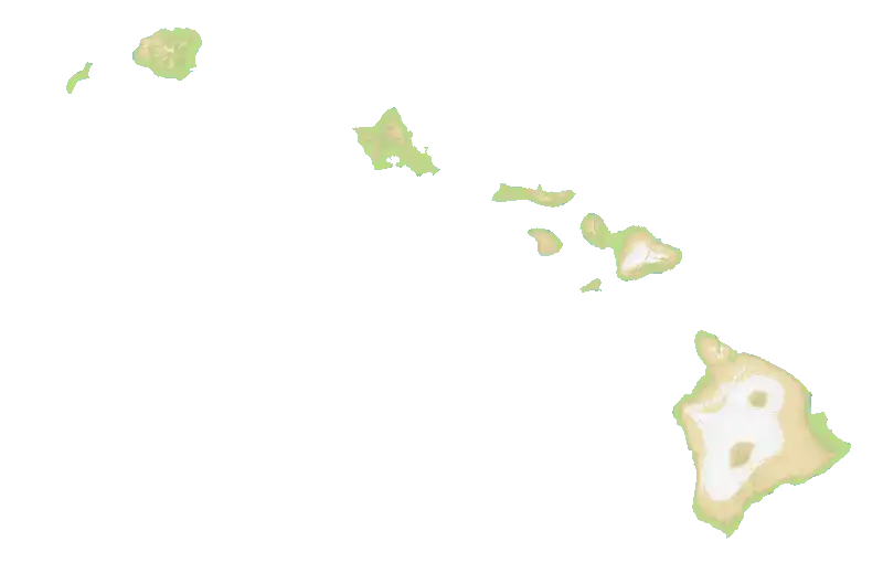
## Description:
Add Hawaii as a new regional map. Features 9 nations across the Hawaiian
island chain (Niihau, Kauai, Oahu, Molokai, Lanai, Kahoolawe, Maui,
Kona, Hilo). ~~612K land tiles at 3920x2544~~ 408K land tiles at
3200x2076, terrain generated from real relief data with accurate
volcanic peaks and coastal lowlands. Playlist frequency: 4.
## Checklist
- [x] I have added screenshots for all UI updates
- [x] I process any text displayed to the user through translateText()
and I've added it to the en.json file
- [x] I have added relevant tests to the test directory
- [x] I confirm I have thoroughly tested these changes and take full
responsibility for any bugs introduced
Source:
https://commons.wikimedia.org/wiki/File:USA_Hawaii_relief_location_map.svg
Discord: gabigabogabu
## Description:

A redditor posted this, got quite a few upvotes

<img width="753" height="667" alt="image"
src="https://github.com/user-attachments/assets/9cd6664f-6afa-428a-b85e-4c335dbe1699"
/>


https://www.reddit.com/r/Openfront/comments/1qlrqro/these_maps_are_so_fun_i_want_more/

So I thought why not make another one, this time a bit focused on
traders (tiny islands to trademaxx)
And two big islands (about 50% of the map land tiles). So its big
islands vs small islands.

<img width="1098" height="959" alt="Screenshot 2026-02-10 231024"
src="https://github.com/user-attachments/assets/32368223-bef4-4ba1-a203-29d9afd5b762"
/>

13 nations :)
2200 × 1920

## Please complete the following:

- [X] I have added screenshots for all UI updates
- [X] I process any text displayed to the user through translateText()
and I've added it to the en.json file
- [X] I have added relevant tests to the test directory
- [X] I confirm I have thoroughly tested these changes and take full
responsibility for any bugs introduced

## Please put your Discord username so you can be contacted if a bug or
regression is found:

FloPinguin
## Description:
This PR readds the Yenisei map, with it being about 3 times smaller than
before. I haven't updated the en.json file, as it still has the string
for the map, which was probably forgotten when the map got removed from
the repo.
## Please complete the following:

- [x] I have added screenshots for all UI updates
- [x] I process any text displayed to the user through translateText()
and I've added it to the en.json file
- [x] I have added relevant tests to the test directory
- [x] I confirm I have thoroughly tested these changes and take full
responsibility for any bugs introduced

## Please put your Discord username so you can be contacted if a bug or
regression is found:

DISCORD_USERNAME
Nikola123
<img width="1670" height="200" alt="banner"
src="https://github.com/user-attachments/assets/b6561231-71dc-46dd-a521-453d4e97931f"
/>

## Description:

This proposal adds a new, completely flat map called "The Box," where
players will find themselves on a completely flat landmass and will only
be able to trade by land using trains and factories.

- Map size: 2048×2048 pixels
- Binaries generated with MapGenerator (map.bin, map4x.bin, map16x.bin)
- Integrated into arcade category and multiplayer playlist
- English and Spanish translations added
- 13 nations/bots with unique and thematic names:

> - **Middle Defender (located in the center)**
> - **King of the Corner (located in the top-left corner)**
> - Suspicious Ally
> - Punch Merchant
> - Nuke Thrower
> - Fullsender
> - Factory Builder
> - Front Manager
> - Box Fighter
> - Cage Liberator
> - Train Trader
> - Non-peaceful Bot
> - **Evan The Dev** (special mention)

All other bots are distributed to cover the map evenly.

<img width="838" height="835" alt="Screenshot 2026-01-28 at 17 39 45"
src="https://github.com/user-attachments/assets/4665088d-cb94-4db3-8602-8a22b63bfee2"
/>

## Please complete the following:

- [x] I have added screenshots for all UI updates
- [x] I process any text displayed to the user through translateText()
and I've added it to the en.json file
- [x] I have added relevant tests to the test directory
- [x] I confirm I have thoroughly tested these changes and take full
responsibility for any bugs introduced

## Please put your Discord username so you can be contacted if a bug or
regression is found:

sardidefcon
Resolves#2718
## Description:
Adds go-style error log levels, with an additional ALL log level.
- WARN/ERROR - Only success output
- INFO - Existing output
- DEBUG - New output
- ALL - New output (includes the logs from when removal/performance is
enabled)
In addition
- Add `-verbose` (`-v`), `-log-level`, `-log-removal`, and
`-log-performance` flags to map generator
- No changes to default behavior of `go run .` without the new flags
- excludes test maps from performance warnings (test maps already skip
the removal steps)
- updates readme with the different flags and how they impact the logger
Default run (matches existing)
`go run . >> output.txt 2>&1`
[output.txt](https://github.com/user-attachments/files/24365745/output.txt)
Default run w/ `-verbose` (log level DEBUG)
`go run . -v >> output.txt 2>&1`
[output.txt](https://github.com/user-attachments/files/24365812/output.txt)
Default run w/ `-log-performance`
`go run . -log-performance >> output.txt 2>&1`
[output.txt](https://github.com/user-attachments/files/24365971/output.txt)
Run of just africa w/ all new logging enabled
`go run . -maps=africa -log-level=all >> output.txt 2>&1`
[output.txt](https://github.com/user-attachments/files/24365724/output.txt)
## Please complete the following:
- [X] I have added screenshots for all UI updates
- [X] I process any text displayed to the user through translateText()
and I've added it to the en.json file
- [X] I have added relevant tests to the test directory
- [X] I confirm I have thoroughly tested these changes and take full
responsibility for any bugs introduced
## Please put your Discord username so you can be contacted if a bug or
regression is found:
tidwell
---------
Co-authored-by: coderabbitai[bot] <136622811+coderabbitai[bot]@users.noreply.github.com>
## Description:

Discussed that with Lewis.
Fuze liked the Didier map without the real france more...
So here it is. It won't get added to the playlist, the france version
stays in the playlist.
(Unrelated: Also quickly changed "Europe (classic)" to Europe (Classic)"
to match with "Britannia (Classic)")

<img width="934" height="839" alt="Screenshot 2026-01-10 005646"
src="https://github.com/user-attachments/assets/64925635-c15a-4167-a5bc-5cf7b3b140f8"
/>
<img width="1064" height="961" alt="Screenshot 2026-01-10 003335"
src="https://github.com/user-attachments/assets/9b6aa936-2c33-4a24-8076-a74a4704adc4"
/>
<img width="635" height="427" alt="Screenshot 2026-01-10 003316"
src="https://github.com/user-attachments/assets/e2b46db8-ef0b-4b45-8ea7-711b9b8f7524"
/>


## Please complete the following:

- [X] I have added screenshots for all UI updates
- [X] I process any text displayed to the user through translateText()
and I've added it to the en.json file
- [X] I have added relevant tests to the test directory
- [X] I confirm I have thoroughly tested these changes and take full
responsibility for any bugs introduced

## Please put your Discord username so you can be contacted if a bug or
regression is found:

FloPinguin
## Pathfinding with HPA*

Hi! The primary objective of this PR is to replace per-tile A* with
hierarchical pathfinding - HPA*. In practice, this means we create an
abstract graph on top of the actual map with far fewer points and use it
to decide on general path structure. Only then we go back to tile-level
and build path between selected waypoints. This speeds up long distance
pathfinding by over 1000x in some cases. To make the review easier, it
comes with a benchmark and visual playground.

## PREPROCESSING

H part of HPA* means "hierarchical" and requires preprocessing.

This PR includes pre-processing as part inside `new Game()` constructor.
It takes about 135ms for `giantworldmap` on my machine, which increases
the effective initialization from ~95ms to ~230ms. This time could be
reduced in different ways, which are **out of scope** for this PR.

After confirming the initialization time is bearable on low-end devices,
I argue merging this PR as-is is acceptable tradeoff. It creates small
lag at the beginning of a round but pays for itself in the first minute
of the match.

## Nerdy details

**Architecture**
- HPA*-style hierarchical pathfinding
- 32×32 sectors on minimap with gateway nodes on borders
- Gateway graph built via BFS during preprocessing
- Water component optimization skips unreachable gateway pairs
- A* on gateway graph → local A* within sectors → Bresenham path
smoothing
- Minimap upscaling identical to currently used in MiniAStar

**Key Optimizations**
- Typed arrays instead of high-level primitives
- Stamp-based visited tracking (no need to recreate buffers, O(1)
clearing)
- Optional - enabled by default - caching of tile paths between gateways
- Line of sight smoothing for the final path

## Review Focus

Play with included tools, benchmark and visualization. Pathfinding
should be safe to merge as a black box - you do not need to understand
the details. Outcomes can be tested empirically in-game. Visualize (and
share!) edge cases with included playground. Confirm the 100x speedup is
real with benchmark.

If you plan to dive into the code, I suggest the following order:
- Pathfinding abstraction in `src/core/pathfinding/`
- Pathfinding tests in `tests/core/pathfinding/`
- NavMesh in `src/core/pathfinding/navmesh/` + integration with
`Game.ts`
- Benchmark in `tests/pathfinding/benchmark/`

Do not look at playground's code, it has been created with a clanker.
The design is 100% mine and I spent way too long polishing it, but I
haven't even once edited the code manually. There is probably no
abstraction whatsoever, just do not look at the code, let it play.

## Core Changes

#### Pathfinding (`src/core/pathfinding/navmesh/`)
- HPA* + refinement -> three phased pathfinding: A* over the graph ->
naive path -> refinement
- comes with A* and BFS optimized for for specific needs

#### Pre-Processing (`src/core/pathfinding/navmesh/`)
- identify water bodies to avoid pathfinding between disconnected nodes
- create high-level graph of gateways on top of tile map

#### Abstraction (`src/core/pathfinding/`)

- common `PathFinder` interface that can return full path and also act
as state machine (`.next()`)
- adapters for both new and legacy algorithm with fallback to legacy if
navigation mesh not available

#### Benchmark (`tests/pathfinding/benchmark/`)

- `npx tsx tests/pathfinding/benchmark/run.ts` - no guesswork, numbers
- `npx tsx tests/pathfinding/benchmark/run.ts --synthetic` - 1000s of
synthetic paths
- `npx tsc tests/pathfinding/benchmark/generate.ts` - generate more as
needed, test new maps
- includes ONE synthetic scenario to avoid PR bloat, generate more
locally / later

#### Playground (`tests/pathfinding/playground/`)

- `npx tsx tests/pathfinding/playground/server.ts` - visualize paths
with both new and legacy algorithm

## Benchmarks

### Compared with legacy in default - hand picked - scenario:
```
Initialization: 95.95ms -> 227.29ms
Pathfinding: 3038.43ms -> 6.45ms
Distance: 26972 -> 26810 tiles
```

### 42,000 synthetic routes across all maps
```
Running 42 synthetic scenarios with hpa.cached adapter...

✅ synthetic/achiran                   | Init:    93.42ms | Path:    139.07ms | Dist: 1481630 tiles | Routes: 1000/1000
✅ synthetic/africa                    | Init:    87.14ms | Path:    155.08ms | Dist: 1829414 tiles | Routes: 1000/1000
✅ synthetic/asia                      | Init:    57.60ms | Path:    112.55ms | Dist: 1204082 tiles | Routes: 1000/1000
✅ synthetic/australia                 | Init:    78.18ms | Path:     77.12ms | Dist:  978375 tiles | Routes: 1000/1000
✅ synthetic/baikal                    | Init:    78.26ms | Path:    152.14ms | Dist: 1600016 tiles | Routes: 1000/1000
✅ synthetic/baikalnukewars            | Init:    81.44ms | Path:    165.90ms | Dist: 1699283 tiles | Routes: 1000/1000
✅ synthetic/betweentwoseas            | Init:    29.29ms | Path:    114.99ms | Dist: 1338075 tiles | Routes: 1000/1000
✅ synthetic/blacksea                  | Init:    30.66ms | Path:     93.14ms | Dist:  949217 tiles | Routes: 1000/1000
✅ synthetic/britannia                 | Init:    74.12ms | Path:     85.62ms | Dist:  866752 tiles | Routes: 1000/1000
✅ synthetic/deglaciatedantarctica     | Init:   105.49ms | Path:    192.93ms | Dist: 1574684 tiles | Routes: 1000/1000
✅ synthetic/didier                    | Init:    81.51ms | Path:    153.70ms | Dist: 1734876 tiles | Routes: 1000/1000
✅ synthetic/eastasia                  | Init:    49.29ms | Path:    128.63ms | Dist: 1410270 tiles | Routes: 1000/1000
✅ synthetic/europe                    | Init:    92.55ms | Path:    178.35ms | Dist: 1525216 tiles | Routes: 1000/1000
✅ synthetic/europeclassic             | Init:    33.50ms | Path:    104.40ms | Dist: 1209759 tiles | Routes: 1000/1000
✅ synthetic/falklandislands           | Init:    63.00ms | Path:    107.41ms | Dist: 1080251 tiles | Routes: 1000/1000
✅ synthetic/faroeislands              | Init:    71.91ms | Path:     49.52ms | Dist:  604613 tiles | Routes: 1000/1000
✅ synthetic/fourislands               | Init:    45.75ms | Path:     78.91ms | Dist:  937439 tiles | Routes: 1000/1000
✅ synthetic/gatewaytotheatlantic      | Init:    81.00ms | Path:    257.06ms | Dist: 2555551 tiles | Routes: 1000/1000
✅ synthetic/giantworldmap             | Init:   214.25ms | Path:    220.42ms | Dist: 1976693 tiles | Routes: 1000/1000
✅ synthetic/gulfofstlawrence          | Init:    45.16ms | Path:     96.05ms | Dist: 1014604 tiles | Routes: 1000/1000
✅ synthetic/halkidiki                 | Init:    74.68ms | Path:    149.39ms | Dist: 1546781 tiles | Routes: 1000/1000
✅ synthetic/iceland                   | Init:    58.72ms | Path:     78.16ms | Dist: 1001554 tiles | Routes: 1000/1000
✅ synthetic/italia                    | Init:    29.78ms | Path:    139.93ms | Dist: 1412024 tiles | Routes: 1000/1000
✅ synthetic/japan                     | Init:   161.07ms | Path:    118.65ms | Dist: 1154393 tiles | Routes: 1000/1000
✅ synthetic/lemnos                    | Init:    52.59ms | Path:    136.69ms | Dist: 1481101 tiles | Routes: 1000/1000
✅ synthetic/lisbon                    | Init:    49.27ms | Path:     86.53ms | Dist: 1032011 tiles | Routes: 1000/1000
✅ synthetic/manicouagan               | Init:    53.74ms | Path:    110.52ms | Dist: 1307630 tiles | Routes: 1000/1000
✅ synthetic/mars                      | Init:    29.39ms | Path:     80.55ms | Dist: 1091702 tiles | Routes: 1000/1000
✅ synthetic/mena                      | Init:    26.37ms | Path:    120.09ms | Dist: 1272751 tiles | Routes: 1000/1000
✅ synthetic/montreal                  | Init:    26.08ms | Path:    106.77ms | Dist: 1187736 tiles | Routes: 1000/1000
✅ synthetic/newyorkcity               | Init:    56.60ms | Path:    181.19ms | Dist: 1753875 tiles | Routes: 1000/1000
✅ synthetic/northamerica              | Init:    96.29ms | Path:    123.02ms | Dist: 1217221 tiles | Routes: 1000/1000
✅ synthetic/oceania                   | Init:    52.81ms | Path:     51.96ms | Dist:  482373 tiles | Routes: 1000/1000
✅ synthetic/pangaea                   | Init:    21.29ms | Path:     56.58ms | Dist:  716189 tiles | Routes: 1000/1000
✅ synthetic/pluto                     | Init:    53.89ms | Path:    141.62ms | Dist: 1304362 tiles | Routes: 1000/1000
✅ synthetic/southamerica              | Init:    85.19ms | Path:    123.03ms | Dist: 1301403 tiles | Routes: 1000/1000
✅ synthetic/straitofgibraltar         | Init:    76.68ms | Path:    108.30ms | Dist: 1304592 tiles | Routes: 1000/1000
✅ synthetic/straitofhormuz            | Init:    38.97ms | Path:     67.78ms | Dist:  754920 tiles | Routes: 1000/1000
✅ synthetic/surrounded                | Init:    95.35ms | Path:     90.18ms | Dist: 1017142 tiles | Routes: 1000/1000
✅ synthetic/svalmel                   | Init:    60.58ms | Path:    104.75ms | Dist: 1235501 tiles | Routes: 1000/1000
✅ synthetic/twolakes                  | Init:    62.05ms | Path:     94.54ms | Dist: 1140807 tiles | Routes: 1000/1000
✅ synthetic/world                     | Init:    41.43ms | Path:     93.42ms | Dist:  873406 tiles | Routes: 1000/1000

Completed 42 scenarios
Total Initialization Time: 2796.32ms
Total Pathfinding Time: 5026.64ms
Total Distance: 53160274 tiles
```

## Playground

**That's the fun part**. Watch NavMesh running circles around legacy
`PathFinder.Mini` in real time. Debug inner workings, test edge cases,
share URLs for debugging.


https://github.com/user-attachments/assets/34e2e3f5-fbc1-4b1f-917d-820766e98d5d

## Discord Tag
`moleole`
## Description:

Adds a new detailed Britannia map featuring modern UK, Ireland, and
northern France regions. The previous Britannia map has been preserved
as "Britannia Classic".

<img width="4096" height="5031" alt="United Kingdom"
src="https://github.com/user-attachments/assets/8a6ca3ab-bc91-438f-8ca7-7fdf7c5260b8"
/>

<img width="4096" height="5031" alt="United Kingdom_debug"
src="https://github.com/user-attachments/assets/a9a7bcd2-1dc5-40c6-a547-a7a79e636060"
/>


Changes
Added new Britannia map with modern county/region divisions
Renamed existing Britannia map to "Britannia Classic"
Added map-generator source assets for both maps
Updated GameMapType enum with BritanniaClassic
Configured player counts: 50/30/20 for both maps
Added playlist frequencies: Britannia (5), Britannia Classic (4)
Updated language translations

New Britannia Nations (partial list)
Ireland: Mayo, Kerry, Clare, Meath, and more
Scotland: Highland, Argyll and Bute, and more
England: North Yorkshire, and more
France: Pas-de-Calais
Britannia Classic

The original Britannia map with historical kingdoms (Dumnonia, Dyfed,
Gwent, Gwynedd, Powys, Strathclyde, Dalriata, Wessex, Sussex, Kent,
etc.) is now available as "Britannia Classic".

## Please complete the following:

- [X ] I have added screenshots for all UI updates
- [X ] I process any text displayed to the user through translateText()
and I've added it to the en.json file
- [X ] I have added relevant tests to the test directory
- [X ] I confirm I have thoroughly tested these changes and take full
responsibility for any bugs introduced

## Please put your Discord username so you can be contacted if a bug or
regression is found:

TSProphet

---------

Co-authored-by: Harry <Harry.bath94@gmail.com>
Co-authored-by: iamlewis <lewismmmm@gmail.com>
## Description:

We didn't have a river map and we didn't have a map with a crazy size.
So I made a "Amazon River" map with a crazy size.
280 x 5536!
21 nations based on real locations.
Should be interesting gameplay because you don't have many attack
options, your only escape is the river.
The land tiles size is similar to the achiran and iceland map.

<img width="2442" height="147" alt="Screenshot 2026-01-06 150831"
src="https://github.com/user-attachments/assets/91c4142d-c1e3-4aee-ac49-529b8d9f60c4"
/>

<img width="2324" height="139" alt="Screenshot 2026-01-06 150957"
src="https://github.com/user-attachments/assets/5e049ae5-f32a-495f-afde-9e20257b3676"
/>

Because the map is so wide, it looked really ugly stretched in the
thumbnails. So I added some CSS which removes the thumbnail stretching
of the Amazon River map. We can also use this logic for other thumbnails
which shouldn't get stretched.

In `Maps.ts`, `PublicLobby.ts` and `GameInfoModal.ts`.

## Please complete the following:

- [X] I have added screenshots for all UI updates
- [X] I process any text displayed to the user through translateText()
and I've added it to the en.json file
- [X] I have added relevant tests to the test directory
- [X] I confirm I have thoroughly tested these changes and take full
responsibility for any bugs introduced

## Please put your Discord username so you can be contacted if a bug or
regression is found:

FloPinguin
## Description:
Didier map for the big french youtuber Fuze which already published
several OpenFront videos.
I took the real france, cut away the bordering countries and made it
look like Didier 😄
Gave it eyes, hands and feet.
Made sure we have some rivers, also put Corsica in the right bottom
corner!
It's quite large. Similar to the europe map. Has 42 nations (38 french
cities and 4 funny custom nations for the youtuber).
Made with [TsProphets map
generator](https://github.com/TsProphet94/OpenFrontMapGenerator), QGIS
and GIMP.
For public games I put a rare map frequenzy of 2 because most people
probably don't know Fuze.
@ibnhalwa from discord gave some insider knowledge about Fuze (He's
french, I'm not).
<img width="2100" height="2250" alt="image"
src="https://github.com/user-attachments/assets/5d1c3c45-4b2e-4f60-a02f-89b26f938652"
/>
<img width="1278" height="1218" alt="Screenshot 2026-01-05 184540"
src="https://github.com/user-attachments/assets/6e300bb0-6e9f-4b0f-bad8-94f031d250b1"
/>

## Please complete the following:
- [X] I have added screenshots for all UI updates
- [X] I process any text displayed to the user through translateText()
and I've added it to the en.json file
- [X] I have added relevant tests to the test directory
- [X] I confirm I have thoroughly tested these changes and take full
responsibility for any bugs introduced
## Please put your Discord username so you can be contacted if a bug or
regression is found:
FloPinguin
## Description:

A new map where you basically have to hop from island to island :)
We don't have such a map at the moment.
There is a special center island which isn't necessary to get 80% of the
map.
This map could be very interesting in team games. One hydro will destroy
an entire island.
Size: 1976 x 1976
Nations: 8

<img width="949" height="951" alt="Screenshot 2026-01-02 214219"
src="https://github.com/user-attachments/assets/7139bcc9-6a05-414d-90c1-33cc36dd94fb"
/>

## Please complete the following:

- [X] I have added screenshots for all UI updates
- [X] I process any text displayed to the user through translateText()
and I've added it to the en.json file
- [X] I have added relevant tests to the test directory
- [X] I confirm I have thoroughly tested these changes and take full
responsibility for any bugs introduced

## Please put your Discord username so you can be contacted if a bug or
regression is found:

FloPinguin
## Description:
This PR adds the Two Lakes map, based on the irl area around lake Ohrid
and lake Prespa

Describe the PR.

## Please complete the following:

- [x] I have added screenshots for all UI updates
- [x] I process any text displayed to the user through translateText()
and I've added it to the en.json file
- [x] I have added relevant tests to the test directory
- [x] I confirm I have thoroughly tested these changes and take full
responsibility for any bugs introduced

## Please put your Discord username so you can be contacted if a bug or
regression is found:

DISCORD_USERNAME
Nikola123
## Description:

Introduces the Greek island, Lemnos, as a map. The island is both fun
and challenging to play (because of the terrain and elevation) and this
addition was inspired by Altis from the game [Arma
3](https://armedassault.fandom.com/wiki/Altis). The nation names are set
based on the real landmarks, towns, and regions.

<img width="2190" height="1791" alt="image"
src="https://github.com/user-attachments/assets/a7a6de54-f376-43ac-87da-f20aecfebbe0"
/>

<img width="1994" height="1608" alt="image"
src="https://github.com/user-attachments/assets/bc280780-298f-4342-8313-db6cc27ac188"
/>


## Please complete the following:

- [x] I have added screenshots for all UI updates
- [x] I process any text displayed to the user through translateText()
and I've added it to the en.json file
- [x] I have added relevant tests to the test directory
- [x] I confirm I have thoroughly tested these changes and take full
responsibility for any bugs introduced

## Please put your Discord username so you can be contacted if a bug or
regression is found:

bijx
Resolves#2602
## Description:
tldr: `npm run docs:map-generator`
Adds documentation to the `map-generator` go code.
This has no functional changes, other than the renaming of the package.
I used the github url, though this can be set to anything as long as it
contains a `.` so that the docs parse it correctly. Go doc best
practices seem a little verbose and terse, but attempted to comply
Future Facing (to get these docs viewable without running locally):
- Wait until the -http issue is sorted, then these are easy to
statically host alongside builds
- Could use the legacy `godoc`
- Could do formatting after outputting the `txt` output
## Change List:
- Add documentation to all types/fns in map-generator go code
- Ensure this outputs correctly with `go doc`
- Add `docs:map-generator` command to package.json. This runs `go doc`
in `map-generator` w/ appropriate flags to generate full documentation.
(see notes in readme)
- rename `map-generator` module to work around pkgsite assuming all
packages without a . are stdlib (this makes `-http` work at all)
- Add new sections to README and update existing sections
- Add additional references to locations in the primary code base where
things can be found
- Update documentation in the ts theme files to add output color
mappings - this ensures that everything needed to trace the input file
-> in game rendered asset is fully documented.
## Please complete the following:
- [X] I have added screenshots for all UI updates
- [X] I process any text displayed to the user through translateText()
and I've added it to the en.json file
- [X] I have added relevant tests to the test directory
- [X] I confirm I have thoroughly tested these changes and take full
responsibility for any bugs introduced
## Please put your Discord username so you can be contacted if a bug or
regression is found:
tidwell
## Description:

Adds a map based on the Manicouagan Reservoir in Quebec and credits
OpenTopography

## Checklist:

- [x] I have added screenshots for all UI updates
- [x] I process any text displayed to the user through translateText()
and I've added it to the en.json file
- [x] I have added relevant tests to the test directory
- [x] I confirm I have thoroughly tested these changes and take full
responsibility for any bugs introduced
<img width="1017" height="1017" alt="Screenshot 2025-12-14 214706"
src="https://github.com/user-attachments/assets/030c4bbd-0325-4da4-bef5-71053dc8f183"
/>

## Discord username:

sehentsin
## Description:
This PR adds the Christmas map Svalmel with 5 nations.

Describe the PR.

## Please complete the following:

- [x] I have added screenshots for all UI updates
- [x] I process any text displayed to the user through translateText()
and I've added it to the en.json file
- [x] I have added relevant tests to the test directory
- [x] I confirm I have thoroughly tested these changes and take full
responsibility for any bugs introduced

## Please put your Discord username so you can be contacted if a bug or
regression is found:

DISCORD_USERNAME
Nikola123
Resolves#2594
## Description:
- Added an optional `--maps` flag to the map-generator that allows
passing a subset of maps to process.
- Updated `README.md` w/ documentation for using the new flag
Used the [go/flag](https://pkg.go.dev/flag) package.
Running without the flag, or with no arguments matches existing behavior
of processing all the maps defined in `main.go`
`go run .`
`go run . --maps=`
New behavior is triggered to process a subset of maps by passing the
`--maps` flag. Multiple maps are defined in a comma-separated list
`go run . --maps=world,africa`
Or a single map (useful for map development)
`go run . --maps=fourislands`
If an invalid map is passed, the process aborts and renders the error
```bash
go run . --maps=invalidmapname
Error generating terrain maps: map "invalidmapname" is not defined
exit status 1
```
By using the default flag package, we get `--help` for free:
```bash
go run . --help
Usage of <path-to-exe>/exe/map-generator:
-maps string
optional comma-separated list of maps to process. ex: --maps=world,eastasia,big_plains
```
I do not write GO often. Gemini contributed to this syntax.
## Please complete the following:
- [X] I have added screenshots for all UI updates
- [X] I process any text displayed to the user through translateText()
and I've added it to the en.json file
- [X] I have added relevant tests to the test directory
- [X] I confirm I have thoroughly tested these changes and take full
responsibility for any bugs introduced
## Please put your Discord username so you can be contacted if a bug or
regression is found:
tidwell
I'd like to submit some PRs in the future to add additional options for
logging and debugging to the map-generator, however I don't want to
introduce any code style changes in feature requests.

## Description:

I noticed there was not any style guide or formatting being done for the
go files, and went with the simplest built-in approach w/ [go
fmt](https://go.dev/blog/gofmt)

- Adds a `format:map-generator` npm command that will run the default
`go fmt` in the `map-generator` directory to format the go code.
- Runs the formatter and commits the changes to `main.go` and
`map_generator.go`
- Updates the `map-generator` README:
  - Updated location for generated files
  - Updated Links to use markdown links
  - Add `info.json` example
  - Add in-game enabling instructions with list of files to modify
  - Add development tools section with format command

## Please complete the following:

- [X] I have added screenshots for all UI updates
- [X] I process any text displayed to the user through translateText()
and I've added it to the en.json file
- [X] I have added relevant tests to the test directory
- [X] I confirm I have thoroughly tested these changes and take full
responsibility for any bugs introduced

## Please put your Discord username so you can be contacted if a bug or
regression is found:

tidwell