**Add approved & assigned issue number here:**

N/A — maintainer follow-up to #4227.

## Description:

Follow-up to #4227, finishing the "info.json is the single source of
truth" refactor.

**Maps.gen.ts now generates one `MapInfo` interface and a `maps` list**
instead of parallel lookup records. `mapCategories`,
`mapTranslationKeys`, and `multiplayerFrequency` are gone — consumers
read the list directly (`map.categories`, `map.translationKey`,
`map.multiplayerFrequency`). MapPicker got simpler in the process: it
renders from `MapInfo` objects, so the reverse
`Object.entries(GameMapType)` lookup to recover the enum key is gone.
The featured-rank sort moved out of the Go codegen into the picker,
where the presentation concern belongs.

**`SPECIAL_TEAM_MAPS` moves into info.json** as an optional
`special_team_count` field (set on the same 17 maps with the same
values). MapPlaylist derives its map from the generated list;
`SPECIAL_TEAM_FORCE_CHANCE` and the frequency multiplier behavior are
unchanged.

**The en.json `map` section is now generated.** A new optional
`display_name` field in info.json (defaulting to `name`) is written to
`resources/lang/en.json` by the generator, preserving the section's
non-map UI keys (`map`, `featured`, `all`, `favorites`, `random`). The 8
maps whose English display name intentionally differs from the frozen
enum value (e.g. `MENA`, `Milky Way`, `Europe (Classic)`, `Baikal (Nuke
Wars)`) declare it via `display_name`, so no display text changes. The
section is emitted alphabetically; since #4232 already sorted en.json
and every value matches, regeneration is byte-identical and this PR has
no en.json diff. Other languages remain Crowdin-managed.

The generator also now validates `translation_key` is exactly
`map.<folder>` and `special_team_count >= 2`. MapConsistency tests
compare info.json directly against the generated list and the en.json
section, and fail with a "run `npm run gen-maps`" message on drift. No
behavior changes: enum values, playlist frequencies, special-team
counts, featured order, and display names are all byte-identical.

## Please complete the following:

- [x] I have added screenshots for all UI updates (no UI changes —
internal refactor, rendering output identical)
- [x] I process any text displayed to the user through translateText()
and I've added it to the en.json file
- [x] I have added relevant tests to the test directory

## Please put your Discord username so you can be contacted if a bug or
regression is found:

evanpelle

🤖 Generated with [Claude Code](https://claude.com/claude-code)

---------

Co-authored-by: Claude Fable 5 <noreply@anthropic.com>
**Add approved & assigned issue number here:**

N/A — maintainer refactor.

## Description:

Makes each map's `info.json` the single source of truth for map metadata
— adding a map is now a folder with `image.png` + `info.json`, a
`gen-maps` run, and an en.json display name.

**info.json / manifest.json carry full map metadata.** Every
`map-generator/assets/maps/<map>/info.json` declares `id` (the
`GameMapType` enum key), `name` (the enum value — wire format, unchanged
for all 94 maps), `translation_key`, `categories`, and
`multiplayer_frequency` (the public-playlist weight that used to be the
`FREQUENCY` record in MapPlaylist.ts). The generator validates
everything and mirrors it into `resources/maps/<map>/manifest.json`. 23
stale info.json `name` values were normalized to the canonical enum
value; enum values are byte-identical, so replays and stored game
configs are unaffected.

**The generator emits the TypeScript and discovers maps itself.** New
`map-generator/codegen.go` generates `src/core/game/Maps.gen.ts`
(`GameMapType`, `GameMapName`, `mapCategories`, `mapTranslationKeys`,
`multiplayerFrequency` — now a full `Record<GameMapName, number>`,
killing the old `Partial`) on every run; `Game.ts` re-exports it. The
hardcoded map registry in `main.go` is gone — maps are auto-discovered
from the `assets/maps` / `assets/test_maps` directories. MapConsistency
tests fail with a "run `npm run gen-maps`" message if info.json,
manifest.json, and Maps.gen.ts drift. The tracked
`map-generator/map-generator` binary is rebuilt to match.

**New categories: continents + world/cosmic/tournament/other,
multi-category support.** `continental`/`regional`/`fantasy`/`arcade`
are replaced by `featured`, `world`, `europe`, `asia`, `north_america`,
`africa`, `south_america`, `oceania`, `antarctica`, `cosmic`,
`tournament`, and `other`. Maps can list multiple categories, so
straddlers (Black Sea, Bosphorus, Caucasus, Between Two Seas, Bering
Sea/Strait, Mena, Strait of Gibraltar, Hawaii, Arctic) appear under both
regions. Featured is itself a category (same 7 maps as before).
MapPlaylist keeps its arcade exclusion via an explicit set.

**Map picker UI.** Two tabs: **Featured** (default — featured maps plus
a Favorites section when maps are starred) and **All** (one prominent
collapsible bar per category with a map count, collapsed by default).
The selected map is prepended to the featured grid when it lives
elsewhere. `getMapName()` resolves through the generated
`mapTranslationKeys`, which also fixes tourney maps never resolving a
valid translation key.

## Please complete the following:

- [ ] I have added screenshots for all UI updates (maintainer change —
picker described above)
- [x] I process any text displayed to the user through translateText()
and I've added it to the en.json file
- [x] I have added relevant tests to the test directory

## Please put your Discord username so you can be contacted if a bug or
regression is found:

evanpelle

🤖 Generated with [Claude Code](https://claude.com/claude-code)

---------

Co-authored-by: Claude Fable 5 <noreply@anthropic.com>
Resolves#4182
## Description:
Adds "Titan" (real moon of Saturn with methane seas) map . Uses new
random spawn nation feature by FloPinguin.
https://github.com/openfrontio/OpenFrontIO/pull/4156
Also adds new Cosmic map category. The "Other" map category has become a
wastebasket of unrelated maps, and with increasing number of maps, i
think its a good addition to have better categories for these maps.
I figured these 2 changes should go together since im adding a cosmic
map, and a cosmic category.
proof of nations spawning randomly and how the cosmic category looks in
the menu:
https://github.com/user-attachments/assets/b84bd3ef-6b8f-46fe-a6ea-ea5e79c6dc00
## Please complete the following:
- [x] I have added screenshots for all UI updates
- [x] I process any text displayed to the user through translateText()
and I've added it to the en.json file
- [x] I have added relevant tests to the test directory
## Please put your Discord username so you can be contacted if a bug or
regression is found:
tri.star1011
---------
Co-authored-by: Evan <evanpelle@gmail.com>
Resolves#4148
## Description:
Adds "Juan de Fuca Strait" map. This is the Strait in Washington and
British Columbia: https://en.wikipedia.org/wiki/Strait_of_Juan_de_Fuca
This map is meant to be a brand new 3-team way map, since all the team
maps we have are either made for 2 or 4 teams.
The map is bumped towards this gamemode similar to how Baikal is bumped
to 2 teams.
Map also has Additional Nations, for a total fof 62, for Human vs
Nations and solo games
<img width="1365" height="602" alt="image"
src="https://github.com/user-attachments/assets/9cb86727-db06-4fcb-bee4-85e7b5d47d15"
/>
<img width="1319" height="488" alt="image"
src="https://github.com/user-attachments/assets/13fd9a01-7ec6-49ab-81c3-40b566cbf6e0"
/>
data from OpenTopography, already credited
## Please complete the following:
- [x] I have added screenshots for all UI updates
- [x] I process any text displayed to the user through translateText()
and I've added it to the en.json file
- [x] I have added relevant tests to the test directory
## Please put your Discord username so you can be contacted if a bug or
regression is found:
tri.star1011
> **Before opening a PR:** discuss new features on
[Discord](https://discord.gg/K9zernJB5z) first, and file bugs or small
improvements as
[issues](https://github.com/openfrontio/OpenFrontIO/issues/new/choose).
You must be assigned to an `approved` issue — unsolicited PRs will be
auto-closed.

**Add approved & assigned issue number here:**

Resolves #4152(issue number)

## Description:


- Adds a map of Hong Kong. The size is 2781x1997 with land area of 41%
(2.2mil pixels). The islands, straits, harbors, coastlines and
peninsulas make for some very intersting gameplay.
- HK is the second densest place on earth. To simulate this, there are
71 nations based on districts, parks, islands, etc. (Kowloon and HK
Island are so crowded with nations, there may be only 1-2 tribes that
spawn there!)
- Large coastal plains, passes and mountain ranges across islands and
the mainland

map image
<img width="2781" height="1997" alt="hk-improvedriver"
src="https://github.com/user-attachments/assets/ef324fca-88f7-487c-adb0-fa31fc370458"
/>

showcase https://www.youtube.com/watch?v=DosBDttQVmE

## Please complete the following:

- [x] I have added screenshots for all UI updates
- [x] I process any text displayed to the user through translateText()
and I've added it to the en.json file
- [x] I have added relevant tests to the test directory

## Please put your Discord username so you can be contacted if a bug or
regression is found:

DISCORD_USERNAME crunchybbbbb

---------

Co-authored-by: RickD004 <realtacoco@gmail.com>
Resolves#4187
## Description:
Add Map - World Inverted
1248x2500, 1,561,000 land tiles
~100 standard. Over 250+ total.
https://www.youtube.com/watch?v=w2LVZQXZoaUhttps://discord.com/channels/1284581928254701718/1509034328766812210
## Please complete the following:
- [X] I have added screenshots for all UI updates
- [X] I process any text displayed to the user through translateText()
and I've added it to the en.json file
- [X] I have added relevant tests to the test directory
## Please put your Discord username so you can be contacted if a bug or
regression is found:
PlaysBadly
Resolves#4080
## Description:
Add Map Chopping Block
https://youtu.be/NpX73lHiKO8
Increased multiplier for 4 player team games and water nukes (plug in
center among other shortcuts). This map was made as a faster alternative
to Labyrinth. Map has been modified since last submission to be 'less
crazy'.
## Please complete the following:
- [X] I have added screenshots for all UI updates
- [X] I process any text displayed to the user through translateText()
and I've added it to the en.json file
- [X] I have added relevant tests to the test directory
## Discord username:
PlaysBadly
Resolves#4098
## Description:
Adds Southeast Asia map for v32. Very requested map. 31 default nations
(with an extra 31 named for HvN).
Map for intense warship and naval warfare with many, many islands. Also
adds flags of the region to be used by nations in the map. More info
specified in issue
https://github.com/user-attachments/assets/b4151db4-825a-4c1c-8bf8-7b760ae056d2
## Please complete the following:
- [x] I have added screenshots for all UI updates
- [x] I process any text displayed to the user through translateText()
and I've added it to the en.json file
- [x] I have added relevant tests to the test directory
- [x] I confirm I have thoroughly tested these changes and take full
responsibility for any bugs introduced
## Please put your Discord username so you can be contacted if a bug or
regression is found:
tri.star1011
## Description:
Fixes#4069
Adds map of the Caribbean sea and its islands. Archipelago map with lots
of islands, lots of water and a lot of trade.
This map has multiple large landmasses of similar size to prevent
steamrolls (the largest islands and landmasses are around 30%), and
many, many small islands where players can survive and trade. Players
will have to island hop in order to win. 34 nations of Caribbean
countries and territories, with an extra 28 AdditionalNations for a
total of 62 nations for crowded HvN.
Heavy Island maps are very popular in the broader community and we dont
have one for v32, so i figured it would be nice to have a very requested
and popular world location
570k land tiles, fairly small for a map, would be right placed before
World (600k tiles). Also adds some flags of caribbean regions.
https://github.com/user-attachments/assets/9eae81ec-58eb-4594-89fd-2f95742f8b3a
Terrain source from OpenTopography, already credited. No modification to
the tests are needed for new maps added in Game.ts
## Please complete the following:
- [x] I have added screenshots for all UI updates
- [x] I process any text displayed to the user through translateText()
and I've added it to the en.json file
- [x] I have added relevant tests to the test directory
- [x] I confirm I have thoroughly tested these changes and take full
responsibility for any bugs introduced
## Please put your Discord username so you can be contacted if a bug or
regression is found:
tri.star1011
If this PR fixes an issue, link it below. If not, delete these two
lines.
Resolves#4055
## Description:
Adds a 512*512 onion map with 3 nations (Leafer Confederation, Outer
Enclave and Inner Tribe)
<img width="128" height="128" alt="thumbnail"
src="https://github.com/user-attachments/assets/8d97d8dc-6286-4e79-a459-767c936d49ec"
/>
## Please complete the following:
- [x] I have added screenshots for all UI updates
- [x] I process any text displayed to the user through translateText()
and I've added it to the en.json file
- [x] I have added relevant tests to the test directory
- [x] I confirm I have thoroughly tested these changes and take full
responsibility for any bugs introduced
## Please put your Discord username so you can be contacted if a bug or
regression is found:
tktk1234567
## Description:

"A high-stakes naval theater where empires clash over narrow corridors,
bottleneck straits, and heavily fortified shorelines."

Modeled to the exact strategic proportions of the classic Black Sea map,
Yellow Sea shifts the focus of global conflict to East Asia. The map is
defined by its massive central body of water, making naval dominance
absolutely essential for survival. However, unlike wide-open oceans,
control of the Yellow Sea is entirely dictated by its unique coastal
geography.
The Shandong And Liaoning Peninsulas are The definitive feature of the
map. Two massive, opposing peninsulas project deep into the sea, acting
as natural, heavily contestable daggers. They create tight naval choke
points in the central waters while forcing land-based players into
brutal, linear frontlines where every pixel of territory is bought with
blood.
The Continental Rim: A sprawling mainland coast wraps around the
northern and western edges of the map, offering expansive land routes
for players who prefer sweeping land invasions over amphibious assaults.

Scale Class: Medium

Gameplay Style: Naval/Land Hybrid, Tactical Choke Points, Frontline
Bottlenecks

Nations: 8
North Korea South Korea Liaoning Shandong Beijing Hebei Tianjin Jilin


description mostly generated by google gemini ai

## Please complete the following:

- [x] I have added screenshots for all UI updates
- [x] I process any text displayed to the user through translateText()
and I've added it to the en.json file
- [x] I have added relevant tests to the test directory
- [x] I confirm I have thoroughly tested these changes and take full
responsibility for any bugs introduced

## Please put your Discord username so you can be contacted if a bug or
regression is found:

DISCORD_USERNAME crunchybbbbb

<img width="1660" height="1266" alt="Screenshot 2026-05-24 220103"
src="https://github.com/user-attachments/assets/800c6732-677d-44f1-ba5c-c60da5f199e0"
/>


<img width="1500" height="1152" alt="yellow_sea2"
src="https://github.com/user-attachments/assets/9b3ba34a-3f9c-4485-9235-f953fd07be4c"
/>

Game play video https://youtu.be/IcRPTM0rHM0

---------

Co-authored-by: RickD004 <realtacoco@gmail.com>
## Description:
Labyrinth is a maze type map. My attempt at making a more chess style
board for play. Games with bots appear stable at over 45min average run
times. The map has been setup for team spawn zones for 2, 3, 4, 5, 6,
and 7 teams. Some of the team spawns for odd numbers are experimental
and I would like to see how they play out with live players. Additional
nation names included. There are other design factors like each of the
large squares being within the blast radius of a hydro; small islands
are within the blast radius of nukes.
This is meant as a slower playing game. My intentions are to get some
sort of literal rotation of the map in the future if easily implemented.
That way every time players load the game there would be some
randomization.
As an additional note one of my last edit to the map was the "+" shape
to the islands to allow train passage. Zooming out I can see now that
the pattern is squares and + through out. Did not fully intend on that,
but it felt like good vibes.
https://discord.com/channels/1284581928254701718/1293201128858587207/threads/1497062552784605316https://www.youtube.com/watch?v=e8c-TylT4hshttps://www.youtube.com/watch?v=0-yqrfr3nv0
## Please complete the following:
- [x] I have added screenshots for all UI updates
- [x] I process any text displayed to the user through translateText()
and I've added it to the en.json file
- [x] I have added relevant tests to the test directory
- [x] I confirm I have thoroughly tested these changes and take full
responsibility for any bugs introduced
## Please put your Discord username
PlaysBadly
---------
Co-authored-by: RickD004 <realtacoco@gmail.com>
## Description:

Add map of korean peninsula. Size 1092x2149
Nations: 35
based on provinces

## Please complete the following:

- [x] I have added screenshots for all UI updates
- [x] I process any text displayed to the user through translateText()
and I've added it to the en.json file
- [x] I have added relevant tests to the test directory
- [x] I confirm I have thoroughly tested these changes and take full
responsibility for any bugs introduced

## Please put your Discord username so you can be contacted if a bug or
regression is found:

DISCORD_USERNAME
crunchybbbbb @crunchybbbbb_59469


<img width="1092" height="2149" alt="Korea-2"
src="https://github.com/user-attachments/assets/874100e8-4a68-4f57-b2f7-49aa87b8194d"
/>

two teams nations war video https://www.youtube.com/watch?v=n4h7GAfAHTM

---------

Co-authored-by: Ricky G.P. <realtacoco@gmail.com>
## Description:

Adds map of the Balkan Peninsula and surroundings. Heavily requested map
with multiple posts on the Discord all with over 10 or 20 upvotes.

23 NPC/Nations based on countries and relevant regions of the area. Adds
an extra 39 nations for crowded Humans vs Nations gamemode for a total
of 62 NPCs, based on regions of multiple countries. Also some flags for
some regions.

Source from NASA DEM, already credited

Photo of base map, and 62 HvN:


<img width="614" height="588" alt="Captura de pantalla 2026-05-24
030105"
src="https://github.com/user-attachments/assets/5742a4c3-1b1f-4ca7-858d-91529861dd81"
/>

<img width="548" height="547" alt="image"
src="https://github.com/user-attachments/assets/758d8ad0-1515-41b8-8d42-14e76cdd54ed"
/>

This map completes the quartet row of "polemic" maps for v32

<img width="678" height="119" alt="image"
src="https://github.com/user-attachments/assets/9e6f4ef1-f0cc-48ea-a59f-b7ff69033b73"
/>

## Please complete the following:

- [x] I have added screenshots for all UI updates
- [x] I process any text displayed to the user through translateText()
and I've added it to the en.json file
- [x] I have added relevant tests to the test directory
- [x] I confirm I have thoroughly tested these changes and take full
responsibility for any bugs introduced

## Please put your Discord username so you can be contacted if a bug or
regression is found:

tri.star1011
## Description:

Adds Map of the Indian Subcontinent, with indian and pakistani states
and surrounding countries, important rivers like the Ganges, Brahmaputra
and Indus, and Tibet/ theHimalayas

2M land pixels and 52 Nations (i think its fitting that India has the
most nations of a regional map, only continental maps have more)

Should be nice to boost whatever indian playerbase this game might have.
This region also doesnt have any representation aside from continental
maps

<img width="584" height="598" alt="image"
src="https://github.com/user-attachments/assets/4089049a-800b-4e37-ab34-2afc5de821e8"
/>
<img width="418" height="462" alt="image"
src="https://github.com/user-attachments/assets/a68e2424-5972-4105-86c9-0312ab095024"
/>

Elevation data from NASA DEM, already credited in CREDITS.md

No reference test is needed, the test suite automatically iterates over
all GameMapType enum values — no map is hardcoded by name in the tests

## Please complete the following:

- [x] I have added screenshots for all UI updates
- [x] I process any text displayed to the user through translateText()
and I've added it to the en.json file
- [x] I have added relevant tests to the test directory
- [x] I confirm I have thoroughly tested these changes and take full
responsibility for any bugs introduced

## Please put your Discord username so you can be contacted if a bug or
regression is found:

tri.star1011
## Description:

Adds map of Venice. A relatively small map (similar land area to World)
for heavy trade and lots of boating.

Because of the very low difference of elevation of the zone, terrain is
instead used to show buildings.

Map source from OpenStreetMap, already credited in CREDITS.md

Very requested map, with 2 discord posts suggesting it with +15 upvotes
each

<img width="794" height="569" alt="image"
src="https://github.com/user-attachments/assets/ca7d44f2-cfc9-4e93-b7d4-43dbe62f74d4"
/>

## Please complete the following:

- [x] I have added screenshots for all UI updates
- [x] I process any text displayed to the user through translateText()
and I've added it to the en.json file
- [x] I have added relevant tests to the test directory
- [x] I confirm I have thoroughly tested these changes and take full
responsibility for any bugs introduced

## Please put your Discord username so you can be contacted if a bug or
regression is found:

tri.star1011
## Description:

Renames TheStraits map. The people that suggested this map told me they
would prefer a more specific name for the map, rather than the generic
one it has right now. So im renaming it into Danish Straits

This map is for v32, it has not been released, it should be fine to
rename


## Please complete the following:

- [x] I have added screenshots for all UI updates
- [x] I process any text displayed to the user through translateText()
and I've added it to the en.json file
- [x] I have added relevant tests to the test directory
- [x] I confirm I have thoroughly tested these changes and take full
responsibility for any bugs introduced

## Please put your Discord username so you can be contacted if a bug or
regression is found:

tri.star1011
## Description:

Adds map "Northwest Passage", map of the Canadian Arctic Archipelago ,
Greenland and surroundings. "Northwest Passage" (NWP) is the sea lane
between the Atlantic and Pacific oceans
(https://en.wikipedia.org/wiki/Northwest_Passage) .

21 default nations, based on the towns of the region.

This map uses the brand new additionalNations feature made by FloPinguin
https://github.com/openfrontio/OpenFrontIO/pull/3902 . Adds 39 extra
nations for a total of 60 nations (so that in gamemodes like Humans vs
Nations all the nations have names of real places)

Comparison:
- Map with default nations
- Map with extra named nations, tested by raising the number of nations
in Solo

<img width="1050" height="412" alt="image"
src="https://github.com/user-attachments/assets/12ed94f1-0615-4fb3-b0d0-dcecb65006ea"
/>
<img width="1089" height="436" alt="image"
src="https://github.com/user-attachments/assets/6e7c11bf-7382-4e36-9433-229a9d463b68"
/>

Terrain source from OpenTopography, already credited in CREDITS.md

## Please complete the following:

- [x] I have added screenshots for all UI updates
- [x] I process any text displayed to the user through translateText()
and I've added it to the en.json file
- [x] I have added relevant tests to the test directory
- [x] I confirm I have thoroughly tested these changes and take full
responsibility for any bugs introduced

## Please put your Discord username so you can be contacted if a bug or
regression is found:

tri.star1011
## Description:

**Adds "The Straits" map:**

A map located around Denmark and the many surrounding straits: Kattegat,
Skagerrak and the Danish straits (thus the name, meant to be a creative
name like "Between Two Seas" and "Gateway to the Atlantic"). This map is
themed in the early 1900s, the nations/NPCs are traditional and
historical regions of Sweden-Norway, Denmark and the Germany.

Relatively small map with ~700k land tiles, similar to World

Inspired by this Discord thread with nearly 20 upvotes:
https://canary.discord.com/channels/1284581928254701718/1482089104110911634/1482089104110911634

<img width="365" height="506" alt="image"
src="https://github.com/user-attachments/assets/5ee16218-34c0-4b8b-9f9b-d33f219760b0"
/>

## Please complete the following:

- [x] I have added screenshots for all UI updates
- [x] I process any text displayed to the user through translateText()
and I've added it to the en.json file
- [x] I have added relevant tests to the test directory
- [x] I confirm I have thoroughly tested these changes and take full
responsibility for any bugs introduced

## Please put your Discord username so you can be contacted if a bug or
regression is found:

tri.star1011
## Description:

Format the map lists in Main and MapPlaylist by alphabetical order. Many
maps were already standarized like this, but many recent ones werent.
Ideally, future maps should be added this way too.

Also ran npm run format in these 2 files, as they were not formatted
correctly before.

## Please complete the following:

- [x] I have added screenshots for all UI updates
- [x] I process any text displayed to the user through translateText()
and I've added it to the en.json file
- [x] I have added relevant tests to the test directory
- [x] I confirm I have thoroughly tested these changes and take full
responsibility for any bugs introduced

## Please put your Discord username so you can be contacted if a bug or
regression is found:

tri.star1011
## Description:

Map of the Taiwan and the Chinese Mainland.

Team heavy map like Baikal and Hormuz. Terrain Source from
OpenTopography, already credited

<img width="1800" height="1511" alt="image"
src="https://github.com/user-attachments/assets/45954469-8199-4882-9efe-899c5df87ce4"
/>

I also took the chance to standarize and sort alphabetically the map
lists in main.go and MapPlaylist.ts.

## Please complete the following:

- [x] I have added screenshots for all UI updates
- [x] I process any text displayed to the user through translateText()
and I've added it to the en.json file
- [x] I have added relevant tests to the test directory
- [x] I confirm I have thoroughly tested these changes and take full
responsibility for any bugs introduced

## Please put your Discord username so you can be contacted if a bug or
regression is found:

tri.star 1011

NOTE: If the map gets added, please give contributor to
crunchybbbbb_59469 for this map on Discord. Every file was made by him,
his PR just had weird bugs that didnt allow the PR to be review
automatically

Original PR: https://github.com/openfrontio/OpenFrontIO/pull/3853 by
crunchybbb2-hash
## Description:

Five performance improvements to the map generator, measured on three
maps of increasing size. End-to-end time on `world` improved ~15×, heap
allocations ~19×.

| Map | Before | After | Speedup |
|-----|--------|-------|---------|
| bosphorusstraits (~612K tiles) | 578ms / 594MB | 45ms / 134MB | 13× /
4.4× |
| world (~2M tiles) | 2333ms / 2128MB | 150ms / 553MB | 15× / 3.8× |
| giantworldmap (~8M tiles) | 10701ms / 9300MB | 635ms / 2509MB | 17× /
3.7× |

Changes (one commit each):
- **`--workers` flag**: bounds concurrent map processing to limit peak
memory
- **Flat `[]bool` visited sets**: replaced `map[string]bool` keyed by
`fmt.Sprintf` with flat `[]bool` indexed `x*height+y` — the dominant
cost
- **`neighborCoords` with stack buffer**: eliminates per-call slice
allocation for neighbour lookups
- **`Terrain` struct 24→16 bytes**: field reorder + `uint8` type for
`TerrainType`
- **Nil buffers early**: releases image/terrain arrays as soon as
they're no longer needed
- **BFS mark-visited on push**: each tile enters the queue once instead
of up to 4×, halving queue memory


also fixes a bug (according to Claude):

Here's the bug: createMiniMap downscales by averaging/sampling 2x2
blocks, copying field values across — including Ocean=true from the
parent scale. When a single connected ocean at 1x splits into multiple
disconnected bodies at 4x (because narrow water channels disappear when
you halve resolution), those smaller fragments still carry Ocean=true
from the carryover. The 4x processWater call picks the new largest
fragment and sets it to Ocean=true, but never clears the others — so
multiple disconnected bodies end up flagged as Ocean.

This PR's fix: before the new BFS pass, zero out every Ocean flag, so
only the truly-largest body at the current scale ends up marked.

It's incidental to the perf work but it's a real semantic change — the
on-disk .bin files will differ from main on any map where ocean splits
across downscaling. The PR doesn't mention it, which is why I flagged
it.

---------

Co-authored-by: Copilot <223556219+Copilot@users.noreply.github.com>
## Description:

Starting v32 maps right now!

Adds map of the Middle East. Probably one of the most highly requested
maps.

Very large map (3.4M land pixels, similar to Two Lakes, would become the
2nd or 3rd largest map by land area) of the arabian peninsula and
surrounding regions.
This map has both huge areas of land without water access full of desert
terrain, and massive trade chokepoints, which combined will result in
crazy endgames.

The theme of this map are historical, based on the end of WW1.
Historical flags have been added for the nation NPCs to use.

(High map rotation of 8 since this is probably going to become one of
the most popular maps given the relevancy of the region in real life.)

Terrain source from NASA DEM, already credited.


https://github.com/user-attachments/assets/6a1b345f-fd92-42c2-8f92-154fac4c9733

## Please complete the following:

- [x] I have added screenshots for all UI updates
- [x] I process any text displayed to the user through translateText()
and I've added it to the en.json file
- [x] I have added relevant tests to the test directory
- [x] I confirm I have thoroughly tested these changes and take full
responsibility for any bugs introduced

## Please put your Discord username so you can be contacted if a bug or
regression is found:

DISCORD_USERNAME

tri.star1011
## Description:

Change inspired by Territorial.io . Renames the Mediterranean sea map to
Mare Nostrum, the ancient name of the sea given by the Romans. The NPCs
of the map are already roman provinces, so this change is more thematic
and also adds a creative name like "Gateway to the Atlantic" and
"Between Two Seas"

## Please complete the following:

- [x] I have added screenshots for all UI updates
- [x] I process any text displayed to the user through translateText()
and I've added it to the en.json file
- [x] I have added relevant tests to the test directory
- [x] I confirm I have thoroughly tested these changes and take full
responsibility for any bugs introduced

## Please put your Discord username so you can be contacted if a bug or
regression is found:

tri.star1011
## Description:
Add Map - Los Angeles (With Roads)
Whats NY without LA? What is LA without its roads? Here is a larger map
where I have turned LAs road network into rivers. Nations named to areas
of the city or surrounding area. Map geo data is from OpenTopography. I
stenciled the highways from screenshots of online maps and some artistic
choice.
https://discord.com/channels/1284581928254701718/1482605671697613081/1482605671697613081https://www.youtube.com/watch?v=6td9wiQKE9s
## Please complete the following:
- [x] I have added screenshots for all UI updates
- [x] I process any text displayed to the user through translateText()
and I've added it to the en.json file
- [x] I have added relevant tests to the test directory
- [x] I confirm I have thoroughly tested these changes and take full
responsibility for any bugs introduced
##Discord username
PlaysBadly
---------
Co-authored-by: evanpelle <evanpelle@gmail.com>
## Description:

Adds map of the Baja California peninsula in Mexico. Majority of this
map is brown terrain to simulate the (Sonora) desert
Mexican and American states as NPCs. The peninsula while having little
landmass is balanced by the fact it will be very easy to pirate from it

<img width="503" height="583" alt="Captura de pantalla 2026-04-18
151337"
src="https://github.com/user-attachments/assets/b1acd93a-fbe4-4d17-95b6-5f4c86ec872f"
/>

Relief data from OpenTopography, already credited

## Please complete the following:

- [x] I have added screenshots for all UI updates
- [x] I process any text displayed to the user through translateText()
and I've added it to the en.json file
- [x] I have added relevant tests to the test directory
- [x] I confirm I have thoroughly tested these changes and take full
responsibility for any bugs introduced

## Please put your Discord username so you can be contacted if a bug or
regression is found:

tri.star1011
## Description:

Adds Archipelago Sea map. The island map to end all island maps.

This is a real location in Southwest Finland, famous for being the
archipelago with the most islands in the world.

This map is made for the very loud playerbase who enjoys naval maps.
This is probably the most heavy naval map we are gonna get. Given this
is a very experimental and unorthodox map like amazon or 4islands, it
has a rotation of 3 , low but still should pop in for people who prefer
island maps.


https://github.com/user-attachments/assets/19b32a4f-825b-4b82-aec3-b24c387b9cdd

## Please complete the following:

- [x] I have added screenshots for all UI updates
- [x] I process any text displayed to the user through translateText()
and I've added it to the en.json file
- [x] I have added relevant tests to the test directory
- [x] I confirm I have thoroughly tested these changes and take full
responsibility for any bugs introduced

## Please put your Discord username so you can be contacted if a bug or
regression is found:

tri.star1011
## Description:

(re-submission of older PR because the old one had too many merge
conflicts)

Re-adds and reworks the previously April Fools "Reglaciated Antarctica"
as a new map, this time with proper elevation data: Map of Antarctica
centered in the South Pole.

The "appeal" of this a map is that it has no green terrain. (As such it
has a really low rotation number (of 1). )

This also completes the Continental map category (antarctica was the
only continent out of the traditional 7 missing).


https://github.com/user-attachments/assets/28302464-c533-483e-8a1b-2699093921ff

The base map image is a composite of 2 relief maps from 2 different
sources, both properly credited

## Please complete the following:

- [x] I have added screenshots for all UI updates
- [x] I process any text displayed to the user through translateText()
and I've added it to the en.json file
- [x] I have added relevant tests to the test directory
- [x] I confirm I have thoroughly tested these changes and take full
responsibility for any bugs introduced

## Please put your Discord username so you can be contacted if a bug or
regression is found:

tri.star1011

Co-authored-by: iamlewis <lewismmmm@gmail.com>
## Description:

Re-submission of older PR:
https://github.com/openfrontio/OpenFrontIO/pull/3617
<img width="612" height="396" alt="image"
src="https://github.com/user-attachments/assets/955a0b2e-1df9-4fa3-a389-235f46a90f69"
/>

Regarding Bering Sea and Bering strait maps:
<img width="576" height="87" alt="image"
src="https://github.com/user-attachments/assets/f57031eb-f9c0-4e1e-83ff-204df51bb6c2"
/>
<img width="589" height="93" alt="image"
src="https://github.com/user-attachments/assets/629e71ba-489f-41cf-b67e-2476af8704f2"
/>

Because of mixed opinions about replacing the maps, i propose at least
this temporary compromise: Bering Sea gets added as a new map and Bering
Strait gets its rotation lowered to a small number. Since the classic
maps are probably being taken off rotation, we should have some small
breathing space for the 2 maps.

In the near future we should discuss between mapmakers in the dev server
whether we keep, replace or completely take Bering Strait off rotation,
and/or a community poll.

## Please complete the following:

- [x] I have added screenshots for all UI updates
- [x] I process any text displayed to the user through translateText()
and I've added it to the en.json file
- [x] I have added relevant tests to the test directory
- [x] I confirm I have thoroughly tested these changes and take full
responsibility for any bugs introduced

## Please put your Discord username so you can be contacted if a bug or
regression is found:

tri.star1011
## Description:

Adds map of the Caucasus. This map is made especifically because of the
new update that allows ports to be placed on smaller bodies of water,
rather than just the largest one.

This map has 2 disconnected, large bodies of water of similar size
(Black and Caspian seas), which would create 2 independent trade
systems, creating a more dynamic economy.

<img width="667" height="541" alt="Captura de pantalla 2026-04-13
195810"
src="https://github.com/user-attachments/assets/d980b831-d920-4a2e-9d92-40a7be96ead6"
/>
<img width="539" height="439" alt="Captura de pantalla 2026-04-13
200005"
src="https://github.com/user-attachments/assets/e973a66a-8796-40dc-b8b3-39b49f687609"
/>

## Please complete the following:

- [x] I have added screenshots for all UI updates
- [x] I process any text displayed to the user through translateText()
and I've added it to the en.json file
- [x] I have added relevant tests to the test directory
- [x] I confirm I have thoroughly tested these changes and take full
responsibility for any bugs introduced

## Please put your Discord username so you can be contacted if a bug or
regression is found:

tri.star1011
## Description:
Add Map - Conakry
Dataset from OpenTopography. Map rotated 45 degrees from north. This is
a 'long' map in a similar catagory as Amazon River with public rotation
adjusted to match. Different than Amazon in that its stubbier, one
sided, and has various terrain obstacles. Also its a really cool looking
piece of geography.
https://www.youtube.com/watch?v=OsMDbnnOOkohttps://discord.com/channels/1284581928254701718/1481689305960288477/1481689305960288477
I removed an additional bot from the far left to help balance the map.
Some rivers were extended past realism to help section off the map in
areas. Size of map kept below average intentionally.
## Please complete the following:
- [x] I have added screenshots for all UI updates
- [x] I process any text displayed to the user through translateText()
and I've added it to the en.json file
- [x] I have added relevant tests to the test directory
- [x] I confirm I have thoroughly tested these changes and take full
responsibility for any bugs introduced
## Please put your Discord username
PlaysBadly
## Description:
Adition of Strait of Malacca map

It adds a new map, requested by
Coolson
awildcoolson
Describe the PR.
The map added is a map inspired by the strait of Malacca, it contains
two large landmasses and some islands
## Please complete the following:

- [x] I have added screenshots for all UI updates
- [x] I process any text displayed to the user through translateText()
and I've added it to the en.json file
- [x] I have added relevant tests to the test directory
- [x] I confirm I have thoroughly tested these changes and take full
responsibility for any bugs introduced

## Please put your Discord username so you can be contacted if a bug or
regression is found:

lerithmercano

---------

Co-authored-by: Ricky G.P. <realtacoco@gmail.com>
Co-authored-by: VariableVince <24507472+VariableVince@users.noreply.github.com>
## Description:

Highly requested map. Map of the 5 Great Lakes (Superior, Michigan,
Huron, Erie and Ontario) with adjacent rivers and lakes. Local cities
and towns as nations / NPCs.


https://github.com/user-attachments/assets/157346fa-e3e6-4d63-9f51-46bae002d529

(Kinda obvious we needed this location at some point)

## Please complete the following:

- [x] I have added screenshots for all UI updates
- [x] I process any text displayed to the user through translateText()
and I've added it to the en.json file
- [x] I have added relevant tests to the test directory
- [x] I confirm I have thoroughly tested these changes and take full
responsibility for any bugs introduced

## Please put your Discord username so you can be contacted if a bug or
regression is found:

tri.star1011
## Description:
Re Add map Dyslexdria. I adjusted the rivers to make boat traffic go
through main channels isntead of shortcuts. Flags adjusted. Correct
thumbnail added

## Please complete the following:

- [x] I have added screenshots for all UI updates
- [x] I process any text displayed to the user through translateText()
and I've added it to the en.json file
- [x] I have added relevant tests to the test directory
- [x] I confirm I have thoroughly tested these changes and take full
responsibility for any bugs introduced

## Discord username
Plays Badly
## Description:
Requesting that these 4 maps be added temporarily for the April Fools
holiday. Included are:
- A wider version of the Amazon River to allow for larger ships.
- An edit of The Box with more varied terrain.
- A modification to The World which optimizes play for mobile users.
- A custom remix to Antarctica which re-adds ice to the map.
All maps are edits of existing work. All maps have been added as their
own individual map files rather than edits to existing files for ease of
management.

<img width="912" height="1067" alt="temp"
src="https://github.com/user-attachments/assets/089ef59f-8bdf-4c86-b479-620b8c220c3a"
/>
https://discord.com/channels/1284581928254701718/1483786939332169830

- [x] I have added screenshots for all UI updates
- [x] I process any text displayed to the user through translateText()
and I've added it to the en.json file
- [x] I have added relevant tests to the test directory
- [x] I confirm I have thoroughly tested these changes and take full
responsibility for any bugs introduced

## Discord username

PlaysBadly
## Description:

Adds Mediterranean sea map, from Iberia to Asia. Map contains ancient
Roman Empire provinces and its rivals as Nations.
This map was requested by the dev.

elevation data from Opentopography

<img width="2850" height="1450" alt="image"
src="https://github.com/user-attachments/assets/6aa5ba12-f4f7-414d-a712-b90323f1d796"
/>
<img width="590" height="304" alt="Captura de pantalla 2026-03-27
010038"
src="https://github.com/user-attachments/assets/efd1deea-bd88-4ae2-92a0-47a6626a0c0f"
/>
<img width="585" height="302" alt="Captura de pantalla 2026-03-27
005758"
src="https://github.com/user-attachments/assets/a127696e-fe34-424c-a88d-b86b99a5f414"
/>


## Please complete the following:

- [x] I have added screenshots for all UI updates
- [x] I process any text displayed to the user through translateText()
and I've added it to the en.json file
- [x] I have added relevant tests to the test directory
- [x] I confirm I have thoroughly tested these changes and take full
responsibility for any bugs introduced

## Please put your Discord username so you can be contacted if a bug or
regression is found:

tri.star1011
## Description:

Adds Milky Way galaxy map based on real reconstruction by NASA. Star
density simulated as terrain. Best played in Dark Mode.

Also adds credits to JPL NASA

<img width="532" height="533" alt="Captura de pantalla 2026-03-26
142938"
src="https://github.com/user-attachments/assets/87bb19bb-4e2d-4383-a3e9-6e14b714b84c"
/>

## Please complete the following:

- [x] I have added screenshots for all UI updates
- [x] I process any text displayed to the user through translateText()
and I've added it to the en.json file
- [x] I have added relevant tests to the test directory
- [x] I confirm I have thoroughly tested these changes and take full
responsibility for any bugs introduced

## Please put your Discord username so you can be contacted if a bug or
regression is found:

tri.star1011
## Description:

Introduces 4 new private match maps for the OFM tournament in May.
Includes 2, 3, 4, and 8 player maps. Playtested, and include as many
default nations as the map expects players, named after compass points.
Give it a try at https://tourney-maps.openfront.dev/

<img width="1500" height="1500" alt="image"
src="https://github.com/user-attachments/assets/9138b636-5dd7-4118-82e2-50a5125a7963"
/>

The base images were created from scratch based on prototype designs,
and they were converted from vector versions I made. I haven't decided
on what the names should be for the maps themselves, so for now they're
just `Tourney Map 1`, `Tourney Map 2`, etc. Ideas welcome.


## Please complete the following:

- [x] I have added screenshots for all UI updates
- [x] I process any text displayed to the user through translateText()
and I've added it to the en.json file
- [x] I have added relevant tests to the test directory
- [x] I confirm I have thoroughly tested these changes and take full
responsibility for any bugs introduced

## Please put your Discord username so you can be contacted if a bug or
regression is found:

bijx
## Description:

This PR registers the straitofhormuz map in main.go. This ensures that
the map is processed and included when running the map generator, as it
was previously present in the resources but missing from the generation
pipeline.

## Please complete the following:

- [X] I have added screenshots for all UI updates
- [X] I process any text displayed to the user through translateText()
and I've added it to the en.json file
- [X] I have added relevant tests to the test directory
- [X] I confirm I have thoroughly tested these changes and take full
responsibility for any bugs introduced

## Please put your Discord username so you can be contacted if a bug or
regression is found:

TSProphet
## Description:

Adds Aegean map, a map centered in the Aegean Sea and the aegean islands
between Greece and Turkey. Map has approx. 1M land tiles, size of
1600x2000.

Nations are named after Ancient Greece era city-states and tribes.
Elevation source from OpenTopography, already credited

<img width="1600" height="2000" alt="image"
src="https://github.com/user-attachments/assets/e4f52d6e-bba4-4641-9eac-31e3ddee354e"
/>
<img width="453" height="445" alt="Captura de pantalla 2026-03-08
141256"
src="https://github.com/user-attachments/assets/5d2bc8cf-1e54-461a-ae0f-9bb2dafc2db6"
/>

This has been a heavily requested map in the community, having
suggestions in the Discord, Subreddit and even in some videos (for
example i saw Ultimus Rex suggest an aegean map when asked what maps he
would like in his last stream)

The map is designed so that the greek and turkish main landmasses are
around 400,000 pixels in area, which combined account for around less or
equal to 80% of the map. This means players will have to cross the sea
to win, and to do so they will have to hop across the islands, which
means there will be heavy warship action, instead of having stalemates
like in most island maps where the gap between islands is too large and
players would rather bomb each other.

## Please complete the following:

- [x] I have added screenshots for all UI updates
- [x] I process any text displayed to the user through translateText()
and I've added it to the en.json file
- [x] I have added relevant tests to the test directory
- [x] I confirm I have thoroughly tested these changes and take full
responsibility for any bugs introduced

## Please put your Discord username so you can be contacted if a bug or
regression is found:

tri.star1011
## Description:

Adds San Francisco bay map. 21 nations based on cities and towns of the
area. 1.8M land pixels , size of 2000x1700
Elevation data from Opentopography, already credited.
Map frequency of 3, as to mirror New York map.

<img width="2000" height="1700" alt="image"
src="https://github.com/user-attachments/assets/dc80a2db-6233-4b50-8f07-bd21c23c8b53"
/>

## Please complete the following:

- [x] I have added screenshots for all UI updates
- [x] I process any text displayed to the user through translateText()
and I've added it to the en.json file
- [x] I have added relevant tests to the test directory
- [x] I confirm I have thoroughly tested these changes and take full
responsibility for any bugs introduced

## Please put your Discord username so you can be contacted if a bug or
regression is found:

tri.star1011
## Description:

Adds Arctic map, a map centered about the Geographical North Pole using
an azimuthal equidistant projection. Features Cold War themed countries
and subdivisions as nations. Square map with 1.6M land tiles. Terrain
data from Opentopography and Arctic SDI real relief data

<img width="1830" height="1830" alt="image"
src="https://github.com/user-attachments/assets/0b8b1e42-f477-4ebf-a256-c07536db87d9"
/>

## Please complete the following:

- [x] I have added screenshots for all UI updates
- [x] I process any text displayed to the user through translateText()
and I've added it to the en.json file
- [x] I have added relevant tests to the test directory
- [x] I confirm I have thoroughly tested these changes and take full
responsibility for any bugs introduced

## Please put your Discord username so you can be contacted if a bug or
regression is found:

tri.star1011
## Description:
Introduces Passage, an island filled thin map (like Amazon River but
inverted) which is a long, thin stretch of islands that makes for some
really fun gameplay. I playtested with 3 friends a number of times and
it's great in pretty much all the modes. Naval gameplay on this map is
particularly fun since some islands in the center basically hold the
choke points on trade ships passing from one side to another, making
them hotly contested territory.

<img width="6000" height="400" alt="long map"
src="https://github.com/user-attachments/assets/7904d6f8-e7b8-437d-852e-68a2f006d200"
/>


Describe the PR.

## Please complete the following:

- [x] I have added screenshots for all UI updates
- [x] I process any text displayed to the user through translateText()
and I've added it to the en.json file
- [x] I have added relevant tests to the test directory
- [x] I confirm I have thoroughly tested these changes and take full
responsibility for any bugs introduced

## Please put your Discord username so you can be contacted if a bug or
regression is found:

bijx
## Description:
Add Nile Delta as a new regional map. Features 11 nations across the
delta region (Alexandria, Damietta, Faraskur, Sheremsah, El
Senbellawein, Aga, Mit Ghamr, Cairo, Heliopolis, Memphis, El Mansoura).
1.36M land tiles at 1556x1280, terrain generated from real relief data.
Includes the Suez Canal. Playlist frequency: 4.
## Checklist
- [x] I have added screenshots for all UI updates
- [x] I process any text displayed to the user through translateText()
and I've added it to the en.json file
- [x] I have added relevant tests to the test directory
- [x] I confirm I have thoroughly tested these changes and take full
responsibility for any bugs introduced
Source: https://commons.wikimedia.org/wiki/File:Niledelta_33.svg
Discord: gabigabogabu
## Description:
Adds a new Bosphorus Map (Turkey). One of the key strategic locations in
the world and control access to the Black Sea. Smaller map that most to
facilitate smaller FFA and Team games. Added are a selection of nations
that correspond to the location.
<img width="1000" height="612" alt="image"
src="https://github.com/user-attachments/assets/27a6debc-a33b-4b54-b522-69ab814c39f0"
/>


## Please complete the following:
- [X] I have added screenshots for all UI updates
- [X] I process any text displayed to the user through translateText()
and I've added it to the en.json file
- [X] I have added relevant tests to the test directory
- [X] I confirm I have thoroughly tested these changes and take full
responsibility for any bugs introduced
## Please put your Discord username so you can be contacted if a bug or
regression is found:
TSProphet
---------
Co-authored-by: Ryan <7389646+ryanbarlow97@users.noreply.github.com>
Co-authored-by: iamlewis <lewismmmm@gmail.com>
## Description:
PR to add Bering Strait map. Produced using TOPO data from real world
location, rivers and lakes correct to real world location. The map is
slightly smaller than most so facilitates smaller FFA games or 2 team
game modes.
The centre island has been increased in size to enable better warfare to
capture the strategic location.
<img width="1500" height="918" alt="image"
src="https://github.com/user-attachments/assets/bc9b2e69-cef1-4f21-92b5-4ffdce5812e1"
/>

## Please complete the following:
- [X] I have added screenshots for all UI updates
- [X] I process any text displayed to the user through translateText()
and I've added it to the en.json file
- [X] I have added relevant tests to the test directory
- [X] I confirm I have thoroughly tested these changes and take full
responsibility for any bugs introduced
## Please put your Discord username so you can be contacted if a bug or
regression is found:
TSProphet
---------
Co-authored-by: Ryan <7389646+ryanbarlow97@users.noreply.github.com>
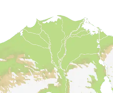
## Description:
Fixes closed PR and adds the new “Alps” map and register it in the
game/map playlist. With 7 geographically accurate nations. Pure large
land map for land warfare only.
<img width="2564" height="1400" alt="Untitled"
src="https://github.com/user-attachments/assets/2c51fad3-7345-46a8-9256-2874d1c4211b"
/>
<img width="2000" height="1837"
alt="551068953-fe4445cd-c0b2-4a5a-b652-1e480e38cdb6"
src="https://github.com/user-attachments/assets/1c466262-e20b-46bc-b782-944cbf6ee62a"
/>

## Please complete the following:
- [X] I have added screenshots for all UI updates
- [X] I process any text displayed to the user through translateText()
and I've added it to the en.json file
- [X] I have added relevant tests to the test directory
- [X] I confirm I have thoroughly tested these changes and take full
responsibility for any bugs introduced
## Please put your Discord username so you can be contacted if a bug or
regression is found:
TsProphet