mirror of
https://github.com/openfrontio/OpenFrontIO.git
synced 2026-06-21 21:04:14 +00:00
## Description: Add Hawaii as a new regional map. Features 9 nations across the Hawaiian island chain (Niihau, Kauai, Oahu, Molokai, Lanai, Kahoolawe, Maui, Kona, Hilo). ~~612K land tiles at 3920x2544~~ 408K land tiles at 3200x2076, terrain generated from real relief data with accurate volcanic peaks and coastal lowlands. Playlist frequency: 4. 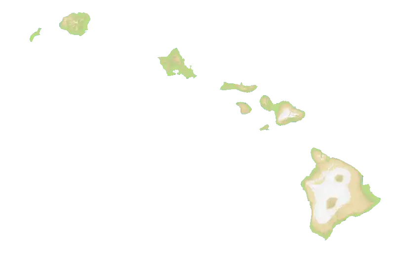 ## Checklist - [x] I have added screenshots for all UI updates - [x] I process any text displayed to the user through translateText() and I've added it to the en.json file - [x] I have added relevant tests to the test directory - [x] I confirm I have thoroughly tested these changes and take full responsibility for any bugs introduced Source: https://commons.wikimedia.org/wiki/File:USA_Hawaii_relief_location_map.svg Discord: gabigabogabu
51 lines
847 B
JSON
51 lines
847 B
JSON
{
|
|
"name": "Hawaii",
|
|
"nations": [
|
|
{
|
|
"coordinates": [283, 281],
|
|
"name": "Niihau",
|
|
"flag": "us"
|
|
},
|
|
{
|
|
"coordinates": [613, 189],
|
|
"name": "Kauai",
|
|
"flag": "us"
|
|
},
|
|
{
|
|
"coordinates": [1424, 525],
|
|
"name": "Oahu",
|
|
"flag": "us"
|
|
},
|
|
{
|
|
"coordinates": [1930, 708],
|
|
"name": "Molokai",
|
|
"flag": "us"
|
|
},
|
|
{
|
|
"coordinates": [1977, 874],
|
|
"name": "Lanai",
|
|
"flag": "us"
|
|
},
|
|
{
|
|
"coordinates": [2145, 1036],
|
|
"name": "Kahoolawe",
|
|
"flag": "us"
|
|
},
|
|
{
|
|
"coordinates": [2287, 900],
|
|
"name": "Maui",
|
|
"flag": "us"
|
|
},
|
|
{
|
|
"coordinates": [2550, 1550],
|
|
"name": "Kona",
|
|
"flag": "us"
|
|
},
|
|
{
|
|
"coordinates": [2900, 1500],
|
|
"name": "Hilo",
|
|
"flag": "us"
|
|
}
|
|
]
|
|
}
|